Lohmen: Over the Schwedenlöcher to Spa town Rathen to the Bastei


- 1:45 h
- 4.82 km
- 211 m
- 194 m
- 118 m
- 312 m
- 194 m
- Start: Car park / Stop Bastei
- Destination: Car park / Stop Bastei
Stop / Car park Bastei - Schwedenlöcher - Amselgrund - Amselsee - Spa town Rathen - Bastei Bridge - Stop / Car park Bastei
Good to know
Pavements
- Unknown (71%)Street (2%)Asphalt (3%)Trail (2%)Path (22%)
Best to visit
- suitableDepends on weather
Directions
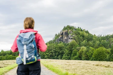
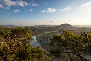
The starting point is the car park or the bus stop in close proximity to the famous Bastei Bridge. In the direction of Bastei, the path turns left towards the "Schwedenlöcher" marked with a "Blue Bar". You walk through a beautiful woodland. "Schwedenlöcher" is the name of a gorge-like ravine that leads down about 700 steps. Before the Schwedenlöcher begin, a detour to the pavilion viewpoint is worthwhile. From here, you have the first impressive rock view towards the Bastei Bridge and into the Wehlgrund valley.
Once in the valley, leave the blue bar trail and walk right through the Amselgrund, past the Grünbach, the Amselsee, and the box office of the rock stage theatre towards the town center of the spa town Rathen. At the height of the Hotel Amselgrundschlösschen, the hiking trail with a signpost to the Bastei branches off to the right. You can comfortably reach the Bastei Bridge via a well-developed path with steps. Lovely views of the Elbe valley are offered along the way.
Do not miss the worthwhile detours to the viewpoints along the way.The hike is also possible in the opposite direction, but note that the over 600 steps in the "Schwedenlöcher" have to be climbed uphill.
Tour information
Cultural Interesting
Loop Road
Stop at an Inn
Equipment
Sturdy footwear is recommended for this route.
Directions & Parking facilities
- Getting there
Coming from Pirna: After leaving Lohmen, turn right towards Bastei after about 3 kilometres.
Coming from Bad Schandau: Via Rathmannsdorf, Porschdorf, Waltersdorf. Turn off at the Hocksteinschänke towards Pirna/Bastei. After leaving Rathewalde, turn left towards Bastei after about 1 kilometre.
Arrival with Google Maps: https://goo.gl/maps/Dcvjy79wZuDjzbXW9
ParkingCar park at the Bastei (approx. 300 meters to the viewpoint)
Car park at the Bastei junction if the Bastei car park is full; bus shuttle to the Bastei
Public transportationArrival/Departure:
Bus line: 237 Stop: Bastei
Literature
Order hiking guides now: Hiking guides.
Author
Yvonne Brückner
Organization
Tourismusverband Sächsische Schweiz
License (master data)
Yvonne Brückner

Author´s Tip / Recommendation of the author
Plan more time than the walking time requires - there are many viewpoints to discover. Perhaps the Amselsee also tempts you with a boat ride (only possible during the summer season).
Safety guidelines
Please observe the trail regulations in the Saxon Switzerland National Park.
Map
Nearby


Download GPX file