Stanserhorn summit route

- 0:30 h
- 1.16 km
- 66 m
- 66 m
- 1,831 m
- 1,895 m
- 64 m
- Start: Stanserhorn mountain station
- Destination: Stanserhorn mountain station
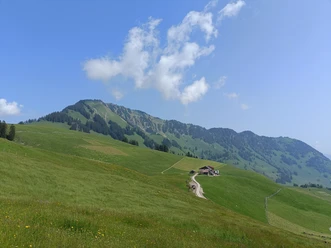
Only thirty minutes of walking time is to be calculated for the summit route – but that is far too little to look from the “Adlerhorst” towards Brünig, to discover the Mönch left of the Eiger, watch the marmots, and feel the 22,000 bovine units. Visiting the revolving restaurant Rondorama or the sun terrace is part of the excursion to the Stanserhorn.
The path from the mountain station to the summit of the Stanserhorn can also be explored virtually here!
Good to know
Pavements
Unknown
Trail
Path
Best to visit
suitable
Depends on weather
Tour information
Loop Road
Loop Road
Mountain Railway Tour
Nature Highlight
Summit
Author
Nidwalden Tourismus
Organization
Nidwalden Tourismus
License (master data)
Nidwalden Tourismus

Nearby

Download GPX file