Stemweder Berge - Rundwanderweg "Rosa Linie"

- 1:55 h
- 6.67 km
- 146 m
- 146 m
- 80 m
- 198 m
- 118 m
- Start: Hiking parking lot "Schwacken Hagen"
- Destination: Hiking parking lot "Schwacken Hagen"
A gentle climb to the highest point of the Stemweder Berg, a detour to the Lemförde orchid farm is possible via the Ems-Hase-Hunte-Else long-distance hiking trail.
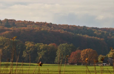
The Stemweder Berg is located in the south-east of the Dümmer Nature Park. At 181 meters above sea level, it is the last elevation before the North German Plain and is bordered to the south by the park-like cultivated landscape of the municipality of Stemwede. To the east of Lake Dümmer is the Oppenweher Moor. The Stemweder Berg consists of limestone from the late Cretaceous period. This soft limestone contains imprints of shells but also whole shells. Various fossils are on display in the Dümmer Museum in Lembruch.The forest consists mainly of beech trees. There are two large stands of the extremely rare woodruff beech forest here. Various historical boundary stones can be discovered in the Stemweder Berg. As a result of the Peace of Westphalia in 1648, Minden and the area south of the Stemweder Berg became part of Brandenburg (Prussia). High-trunk orchards on the edge of the Stemweder Berg provide a habitat for dormice, little owls and various species of bat. Water seeps away quickly in the glacial dry valleys of the Stemweder Berg. Shallow ponds are only present in small areas. In addition to native game such as roe deer, hare, pheasant and fox, the great spotted woodpecker and black woodpecker can also be found. The cowslip, arum, lily of the valley, native orchids and woodruff are also present. This extensive woodland area is accessible via well-developed and marked hiking trails of varying lengths, each of which starts at a hiking car park
.
Good to know
Best to visit
- suitableDepends on weather
Tour information
Familiy-Friendly
Labelling
Loop Road
Loop Road
Nature Highlight
Stop at an Inn
Author
Organization
Tourist Information Dümmerland
License (master data)
Tourist Information Dümmerland

Nearby
Download GPX file