- 1:46 h
- 25.38 km
- 137 m
- 128 m
- 39 m
- 187 m
- 148 m
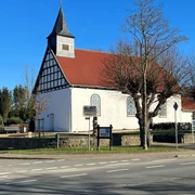
- Start: Meeting point and start of the hiking tour at the hiking parking lot "Zum Grünen Walde" in Stemwede-Oppendorf, Brockumer Str. opposite a former restaurant in the forest.
- Destination: How to start
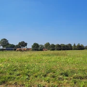
"Forest is a monosyllable, but a world full of wonders. it is the cheapest pharmacy for body and soul". The Stemweder Berg is located in the south-east of the Dümmer Nature Park.181 meters above sea level, it is the last elevation before the North German Plain.The park-like cultural landscape of the municipality of Stemwede adjoins to the south.The Oppenweher Moor is located to the east of Lake Dümmer.The Stemweder Berg consists of limestone from the late Cretaceous period.The forest consists mainly of beech trees and there are two large stands of the extremely rare woodruff beech forest here.Along the route you can discover historical boundary stones, high trunk orchards, which provide habitats for dormice, stone owls and bat species. Native game such as deer, pheasant and fox can also be found here, as well as the cowslip, wood anemone and native orchids in the Stemweder Berg.
Good to know
Best to visit
Directions
The path along the yellow and red dotted line, turn left at the triangle: follow the red dotted path through the Ostenberg.
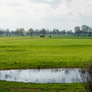
Viewpoint Am Ostenberg: view of the Diepholzer Moorniederung to the north, the village of Oppendorf to the east and then the view sweeps south to the Weser and Wiehengebirge mountains with good visibility as far as the Porta! A magnificent park landscape between the Stemweder mountains and Wiehengebirge. Continue the walk around the edge of the forest to the right. A forest sofa invites you to linger. Flowering hedges with sloes, wild roses and hawthorn enchant the path in spring, and in fall there are fruits to snack on. The woodruff-beech forest is wonderfully distinctive under old copper beeches. In May, orchids such as the white woodland bird's-eye bloom. The red dotted path leads uphill through the forest again. At the crossroads, we come to the natural forest cell, which is described on a sign. The path meets the yellow path, which leads to the left towards the White Path. The hike continues along this main path from Wehdem to Wilhelmshöhe, passing the burial mound, which is explained on a sign. Shortly afterwards, a refuge at Schlichten Brink offers a break. The hike continues along the yellow path past the next crossroads. The highest peak of the Stemweder Berge is located near the radio tower on the Scharfen Berg (180 m). Directly after this, the path leads out of the forest through fields and meadows. The 3rd Berggasthof Wilhelmshöhe is the perfect place to stop for refreshments. The restaurant is open daily except Tuesdays. Tuesday only from 5 pm. There is also a picnic area at the hikers' parking lot directly behind the restaurant. 4. The trail continues north on the yellow trail. The yellow trail meets the pink trail and leads to the Lower Saxony side to the edge of the forest in Quernheim. There are more shelters along the way. The path continues around to the right in the forest. Then turn left out of the forest over the Brockumer Klei. Very good views of Lake Dümmer. The path leads through the field, then turns right back into the forest. Immediately in the forest, turn left onto the yellow dotted path. At the hiking parking lot "Zum Berge", walk uphill again on the pink dotted path. Follow this path through a quarry. The humming holes invite you to try them out. Continue to the Grenzhütte, a particularly nice picnic spot for a rest. Continue along the border path with historic boundary stones to the 5th orchard meadow "Auf dem Bröken", another resting place with a spacious hut. In late summer and fall, when plums, apples or pears are ripening, there is the opportunity to pick some fruit. From there, follow the red dotted path directly back to the starting point. A detour directly uphill leads left onto the blue path and to the Indian chief who guards Pacific trees of life (a story about this). From there directly back to the starting point.
Tour information
Familiy-Friendly
Loop Road
Stop at an Inn
Equipment
Directions & Parking facilities
By car: via the highways A1 (Bremen-Münster), A2 (Hannover-Ruhrgebiet), A30 (Bad Oeynhausen-Osnabrück) or federal highways B51 (Diepholz-Bohmte), B65 (Minden-Bohmte), B239 (Herford-Rahden)
.By train: via the nearest train stations Bohmte, Lemförde, Rahden, Pr. Oldendorf-Holzhausen and Lübbecke.
Always know what's running: The smart number for buses and trains in NRW: 01806 504030 (20 cents/connection from landlines and a maximum of 60 cents/connection from mobile networks).
Additional information
Tailor-made offers for nature-loving groups, excursions with the certified nature and landscape guides Dr. Inge Uetrecht, Tel. 05474-349, http://www.uetrecht.net/ and Hans Möller-Nolting, Tel. 05474-6208
Author
Sabine Denker
Organization
Gemeinde Stemwede
License (master data)

Author´s Tip / Recommendation of the author
Map
Nature experience map Stemweder Berge at www.stemwede.de
Nearby