


- 2:00 h
- 6.71 km
- 122 m
- 128 m
- 371 m
- 499 m
- 128 m
- Start: Hiking parking lot at Stertschultenhof in Cobbenrode
- Destination: Hiking parking lot at Stertschultenhof in Cobbenrode
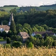
Easy, short route from Cobbenrode.
Good to know
Best to visit
Directions
The start is at Stertschultenhof, from here we cross the federal road and go left over the new cycle path towards Eslohe. After 400 m, at the fish pond, we turn right onto the path towards Bockheim along the Reiserberg. After a short climb, we continue to the T-junction and follow it to the next left turn.
After about 100 m at the crossroads, we turn left into the Henninghauser depression and uphill to the next crossroads. Here right to the paved road (Landenbeck/Henninghausen), then right again and after 100 m left. Uphill to the wayside shrine and then right there.
Follow this path, with a steep ascent, to the T-junction. Here right, again to the paved road. Then right and shortly afterwards left into the forest. Follow the C6 to the paved road (beginning of Cobbenrode). Here through the lower village, on the left is the paddling pool, until the B55. Here right and back to the starting point.
Tour information
Loop Road
Equipment
We recommend sturdy footwear, as well as bringing sufficient food and drinks.
Directions & Parking facilities
Cobbenrode is located between Eslohe and Grevenbrück on the B55.
Parking spaces are available in limited numbers at Stertschultenhof.
In Cobbenrode, use bus line R68 which runs hourly between Grevenbrück and Eslohe.
Timetable information: www.rlg-online.de
With the Schmallenberger Sauerland Card, you can use public transport in the region for free.
Author
Tourist-Information Schmallenberger Sauerland
Organization
Schmallenberger Sauerland Tourismus
License (master data)

Safety guidelines
A rescue point system is installed in Hochsauerlandkreis. You can find rescue points, among other places, on the information boards at junctions and on the hiking signs.
Nearby

