Baumgartenschneid from the Alpbachtal


- 5:00 h
- 11.47 km
- 653 m
- 653 m
- 787 m
- 1,434 m
- 647 m
- Start: Tegernsee, Prinzenweg in the Alpbachtal
- Destination: Tegernsee, Prinzenweg in the Alpbachtal
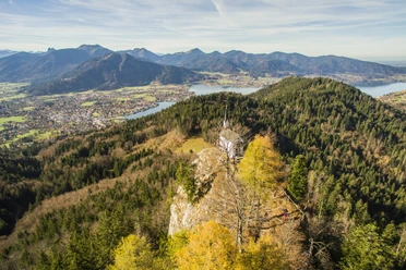
Ideal route for hot summer days. The path runs for a long time through the forest but offers fantastic views of Tegernsee and the surrounding mountains at the top. There is the possibility to stop at the mountain inn Galaun.
Good to know
Best to visit
suitable
Depends on weather
Tour information
Loop Road
Loop Road
Stop at an Inn
Author
Regionalentwicklung Oberland
Organization
Alpenregion Tegernsee Schliersee
License (master data)

Nearby


Download GPX file