- Photos & Map
How would you like to arrive?
- Description
- Good to know
- Nearby
Download GPX file
- 3:20 h
- 11.60 km
- 240 m
- 240 m
- 483 m
- 685 m
- 202 m
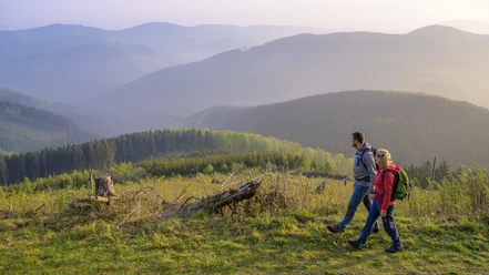
This border story offers a tower ascent, a stay in an idyllic nature reserve and an interesting anecdote from the Sauerland - Wittgenstein border area.
Pure nature in the Schwarzbachtal nature reserve, the discovery of the Hufeisenstein and interesting facts about the Rhine-Weser Tower including a tower ascent. Audio stories about this trail - Hufeisenstein and Rhine-Weser Tower - for download!
Good to know
Best to visit
Directions
As soon as the Rothaarsteig meets the Rothaarsteig access path. We change to the access path (yellow-black markings), which runs parallel to the wide valley floor of the Schwarzbach stream.
Optional: If you would like to discover the Hufeisenstein, leave the access path at the "Hufeisenstein" hiking signpost and follow hiking trail A1 for a short detour in the direction of the Haberg nature reserve. At the height where a forest path branches off to the right, turn left after a few steps "through the bushes". Here you will find the Kurze Dörbach and, with a little attention, the Hufeisenstein. After this short detour, return to the access path.
Follow the access path through the Schwarzbachtal valley until you reach a bridge. Cross the bridge and then turn left. Continue with the hiking sign K or X 18, which we follow back to the Rothaarsteig hiking portal.
Tour information
Cultural Interesting
Loop Road
Stop at an Inn
Equipment
Directions & Parking facilities
Author
Tourist-Information Lennestadt & Kirchhundem
Organization
Tourist-Information Lennestadt & Kirchhundem
Author´s Tip / Recommendation of the author
Refreshments: Rhine-Weser Tower or "Zur Hahnenquelle" restaurant
Flora: Nature reserves
Safety guidelines
Most hiking trails run away from villages and settlements and every hiker has thought about what would happen if an emergency were to occur. How can I be found here? Where am I anyway? Can the emergency services reach me?
In an emergency, things have to move quickly! That's why the hiking trail network in the Lennestadt & Kirchhundem region is equipped with so-called rescue signs throughout. The green and white badges attached to the posts of the signposts have a number that you must give when making an emergency call. This way, the emergency services know exactly where you are and valuable time can be saved.
Map
Tourist Information Lennestadt & Kirchhundem
Hundemstr. 18, 57368 Lennestadt
www.lennestadt-kirchhundem.de
Nearby