Rothaarsteig trail Oberhundemer mountain tour

GPX

PDF

Bookmark

11.49 km long
Round trip
Difficulty: medium
Condition: easy
Great panorama
Hiking
  • 3:34 h
  • 11.49 km
  • 355 m
  • 338 m
  • 419 m
  • 699 m
  • 280 m
  • Start: Hiking portal Haus des Gastes (Kurpark), Oberhundem
Undulating forests with magnificent views, rugged cliffs and fascinating panoramic views on the Kahleberg are complemented on this tour by adventurous path passages on old donkey trails.

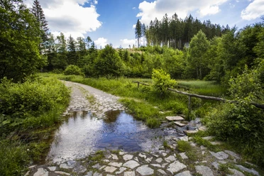
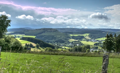
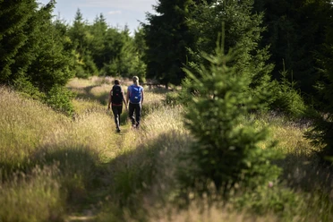
Light and shade, mountain and valley, path and trail, dense forest and inspiring views, rock and meadow - this circular hike, certified with the German Hiking Seal, has something! You follow the Rothaarsteig for a while, the Oberhundem cliffs can be admired at length and when you step out of the forest on the Donkey Trail, which lives up to its name, and see the ensemble of houses in Oberhundem, then you know: it's perfect!

Good to know

Best to visit

suitable
Depends on weather

Directions

Through the hiking portal at the Haus des Gastes, the trail leads slightly uphill through the Oberhundem spa gardens. You only touch the road briefly and turn left onto a dirt track uphill out of the village. You quickly reach a picnic area and enter the forest on a first section of path. You soon reach a small road. Follow the asphalt access road to the hiking parking lot on the left and then begin the steep ascent in the spruce forest on a wide forest path. Only the chaffinch and a couple of nutcrackers can be heard. When you reach the first saddle, the trail continues along the slope. Moss-covered tree stumps with tree fungi are a delight. The first highlight is the Oberhundem cliffs, the next is reaching the Rothaarsteig. A beautiful wooden lounger, part of the Rothaarsteig furniture, follows a little later. Now it's downhill until the Rothaarsteig says goodbye at a hairpin bend. Continue straight ahead to the Wiegequelle spring and a refuge at Böhnenkamp. Turning right here with increasingly beautiful views of the Wildhöfer and its neighbors, the path leads slightly uphill to a viewing point with two benches and information boards. At the next crossroads, "Brie", the trail begins to circle the bare Kahleberg. Fantastic views accompany the passage. In 2007, Kyrill deforested the entire slope. Pioneer plants are now reclaiming the islands of light. The next highlight is the Alpenhaus, officially registered as a village since 2011, population five! Anyway, the former alpine clubhouse of the Essen section (dormitory, several double rooms) is beautifully situated at 650 m above sea level. The start of the final section is somewhat hidden and heralds the most beautiful stage. In the past, the landlord of the Alpenhaus had to transport everything with pack mules. The trail leads through windthrow areas, through forest, sometimes as a path, sometimes as a trail, sometimes as a meadow path. When the edge of the forest is reached after a steep descent, Oberhundem lies ahead of the hiker on the left. Follow the country lane into the village and turn left at the first road junction uphill back to the starting point.  

Tour information

  • Good Connection to public Transport

  • Loop Road

  • Possibility of Accommodation

  • Predicate Trail

  • Premium Trail German Hiker Seal

  • Stop at an Inn

Equipment

The Rothaarsteig leads along numerous natural paths away from agricultural and forestry roads. Weatherproof clothing and sturdy shoes are therefore a must for every hike. We want you to experience the "Path of the Senses" not only "dry" but also with "good" feet.

In our small hiking store at rothaarsteig.de/shop you ll also find a selection of Rothaarsteig articles to prepare for your tour or as a souvenir. We are also happy to recommend the durable and high-quality outdoor equipment from our long-standing partner, the German outdoor equipment manufacturer Tatonka.

Hiking rucksack

With a suitable hiking rucksack, your tour on the Rothaarsteig is twice as much fun! Thanks to their ventilated carrying system, hiking backpacks are very comfortable to wear, as this ensures that sweat can evaporate immediately. They can be fastened with a waist or hip belt and therefore sit firmly on the back with every movement. They are also equipped with a practical holder for hiking poles and often also offer a compartment with a tube outlet for a hydration bladder, so that hydration is ensured at all times.

Here you ll find hiking backpacks from outdoor outfitter Tatonka in various sizes for day hikes and multi-day tours and with different ventilated back systems.

Rainwear

If changeable weather is forecast for your tour on the Rothaarsteig, remember to pack a light rain jacket or rain poncho. They take up virtually no space in your rucksack and also keep out unpleasant wind. Also practical are gaiters, which protect your trouser legs from dirt and moisture.

Our partner, the German outdoor outfitter Tatonka, has high-quality, breathable rain jackets with a minimal pack size, lightweight rain capes and gaiters for your trouser legs to protect them from dirt and moisture.

Here you ll find Tatonka rain jackets for womenYou can find Tatonka rain jackets for men here.

First aid kit

So that you can enjoy your hiking tour on the Rothaarsteig without any restrictions, a first aid kit should be in your rucksack to be on the safe side. After all, nothing is more annoying than not being able to immediately treat a blister on your foot or minor injuries.

The first aid kits from German outdoor equipment manufacturer Tatonka are filled with all the important materials for first aid treatment of injuries and also contain an "outdoor cheat sheet" with a concise and clear guide to the correct behavior in case of emergencies in the great outdoors.

Here you can find the first aid kits from Tatonka!

Food and drinks

On some stages, especially between Lahnhof and Dillenburg, there are unfortunately no refreshment stops along the way. Remember to pack food and drinks, especially here. Sufficient drinks are especially important in summer.

The stainless steel bottles, stainless steel insulated jugs and stainless steel lunch boxes from German outdoor equipment manufacturer Tatonka are not only practical, but also unbreakable and durable.

Directions & Parking facilities

From Altenhundem (accessible via the B517), follow the L553 via Kirchhundem to Oberhundem. There you can park at the Haus des Gastes (at the Kurpark).
Haus des Gastes Oberhundem (at the Kurpark)
Take the train to Altenhundem, from there take the regional bus line R 36 to Oberhundem. Detailed information on the timetable at: www.zws-online.de (Zweckverband Personenverkehr Westfalen Süd).

Additional information

Tourist Information Lennestadt & Kirchhundem
Hundemstr. 18, 57368 Lennestadt-Altenhundem, Tel. +492723 608-800, Fax -801 
info@lennestadt-kirchhundem.de, www.lennestadt-kirchhundem.de

Tourist Information Kirchhundem-Oberhundem Haus des Gastes am Kurpark/Oberhundem
57399 Kirchhundem, Tel. +492723 72675,
post@oberhundem.comwww.oberhundem.com

Literature

We will be happy to send you our free information pack to help you prepare for your hike. At rothaarsteig.de/prospekte you can easily choose what information you need. A good companion for every tour is our Rothaarsteig trail guide with the hosts along the trail and other useful information. 

You can order more hiking tips for the hiking and vacation region of Lennestadt & Kirchhundem easily and free of charge at www.lennestadt-kirchhundem.de.

Author

Tourist-Information Lennestadt & Kirchhundem
Hundemstraße 18
57368 Lennestadt

Organization

Tourist-Information Lennestadt & Kirchhundem

Author´s Tip / Recommendation of the author

Before or after the hike, the spa gardens or the Oberhundem Embroidery Museum invite you to relax and explore.

Safety guidelines

Information about the rescue signs

Most hiking trails run away from villages and settlements and every hiker has thought about what would happen if an emergency were to occur. How can I be found here? Where am I anyway? Can the emergency services reach me?

In an emergency, things have to move quickly! That's why the hiking trail network in the Lennestadt & Kirchhundem region is equipped with so-called rescue signs throughout. The green and white badges attached to the posts of the signposts have a number that you must give when making an emergency call. This way, the emergency services know exactly where you are and valuable time can be saved.

Note on the increased risk of forest fires

Please bear in mind that there is an increased risk of forest fires, especially in summer due to the dry weather! Therefore, please observe the following instructions:

  • Obey the legal smoking ban in the forest - it applies from 1 March to 31 October.
  • Obey the ban on open fires in the forest and within 100 meters of the forest.
  • Take the glass out of the forest - the burning glass effect can start forest fires.
When it is (too) late:
  • Extinguish small incipient fires if you can do so safely. Check the area carefully if necessary.
  • Report fires via "112".
  • Leave the scene of the fire by the shortest route.
The forest will thank you!

Map

Hiking map of Lennestadt & Kirchhundem (scale 1:25,000
Tourist Information Lennestadt & Kirchhundem
Hundemstraße 18, 57368 Lennestadt
www.lennestadt-kirchhundem.de

In our brochure "Rothaarsteig Trails - All circular hiking trails at a glance" you ll find map sections, short explanations and a map of the Breitscheid cave tour for all 13 circular hiking trails. The other 12 Rothaarsteig trails are also shown here with maps, brief explanations and the most beautiful resting places along the route. At rothaarsteig.de/prospekte you can order the booklet conveniently and free of charge to your home or view it online as a PDF or flip catalog. 

We also recommend our Rothaarsteig Trail Hiking Pass. Anyone who has hiked 8 of the 13 trails in total will receive a hiking certificate and a Rothaarsteig pin and will be entered into our annual prize draw. You can also order the hiking pass at rothaarsteig.de/prospekte free of charge to your home or download it directly online.

You can order the original 1:50000 scale Rothaarsteig hiking map on waterproof paper, with up-to-date route guidance and useful markings such as shelters, parking lots, bus stops and much more at rothaarsteig.de/shop and have it sent to your home.

Nearby

Getting there

Rothaarsteig trail Oberhundemer mountain tour
57399 Kirchhundem