Rothaarsteig Trace - Zinser Border Path


- 3:45 h
- 14.44 km
- 246 m
- 250 m
- 456 m
- 667 m
- 211 m
- Start: Hiking car park 'Am Zinsebach'
- Destination: Hiking car park 'Am Zinsebach'
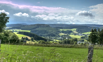
Starting in the picturesque small village of Zinse, the 14 km long circular route follows the meandering Zinsebach, along the Rösper Pond and past the enchanted ponds of the Schwarzbach valley. Many rare plant and animal species such as kingfisher, grey wagtail, and greylag goose can be observed here. From there, the path leads steeply uphill directly along the border to Heinsberg to the Hermeskopf (611 m). Through idyllic beech forests and over narrow paths, you can also count the border stones along the way, which commemorate the old border between Wittgenstein and the Electorate of Cologne Sauerland.
With a detour over the Dreiherrenstein (673 m) – where the territories of the Electorate of Cologne Duchy of Westphalia, the County of Nassau-Oranien, and the Princes of Wittgenstein-Hohenstein met – the path finally leads back along the lonely Zinsebach valley with the small rock cave, the former settlement of Fuchshausen, back to Zinse.

Good to know
Best to visit
Tour information
Cultural Interesting
Loop Road
Loop Road
Author
Nathalie Treude
Organization
Touristikverband Siegen-Wittgenstein e.V.
License (master data)

Nearby
Download GPX file