


- 1:45 h
- 6.02 km
- 166 m
- 166 m
- 357 m
- 475 m
- 118 m
- Start: Hiking board, Arpe
- Destination: Hiking board, Arpe
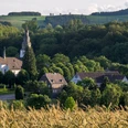
Beautiful circular route with many stunning views of the Hawerland. With dining options in Arpe.
Good to know
Best to visit
Directions
The hike begins in Arpe in the town center near the church. We always follow the hiking sign AR 1. At the hiking board, we turn right and pass by St. Antonius Church. At the end of the path, we turn left and immediately right again. We follow the left paved path. The path steadily ascends until we reach the "Buchhagen Kreuz" with a shelter. Here we turn left and follow the path that leads us to Kückelheim. At the end of the path, we turn left and immediately left again. Now the path leads us along the chapel uphill into a forest. At the next intersection, we choose the left path, which leads us partly uphill; going straight across an intersection, we reach a forest area that we follow until a large intersection.
Here we turn left and have a beautiful view of the Hawerland at the end of the path. We walk left, stay by the power plant on the hiking path, and turn left onto the paved path at the next opportunity. Next, a little before the sports field area, we turn left at a shelter. Walk straight at the entrance to the power plant. After we have passed the substation, we turn right behind some fir trees onto Dornröschenweg (attention, this turn can easily be missed). We follow this path until we reach the road to Arpe. There we turn left and again left at the end of the road until we reach our starting point.
Tour information
Loop Road
Equipment
Directions & Parking facilities
Parking is available at the village hall, at Gasthof Voss Im Arpetal, at the bus stop, or near the church.
Bus line 345 runs in Arpe. To get to the starting point of the route, use the "Arpe" stop.
Timetable information: www.rlg-online.de
With the Schmallenberger Sauerland Card, you can travel for free by bus and train in the region.
Author
Tourist-Information Schmallenberger Sauerland
Organization
Schmallenberger Sauerland Tourismus
License (master data)

Author´s Tip / Recommendation of the author
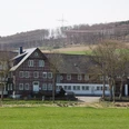
As a place to eat, we recommend Gasthof Voss Im Arpetal, in the village of Arpe.
Safety guidelines
Map
Hiking map Schmallenberger-Sauerland, scale: 1:25,000
Hiking map Bauernland, scale: 1:25,000
Nearby
