- Photos & Map
How would you like to arrive?
- Description
- Waypoints
- Good to know
- Nearby
Download GPX file
- 4:45 h
- 14.97 km
- 337 m
- 926 m
- 805 m
- Start: Car park at the Kegelberg
- Destination: Car park at the Kegelberg
The Hoher Stein
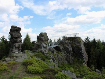
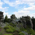
At the junction between Egerland and Vogtland, the rock cliffs of the legendary Hoher Stein rise east of Eubabrunn at an elevation of 777 m above sea level. Dwarfs are said to live inside, and treasures are hidden there. In the times of the Marcomanni, a princely castle once stood here, at the foot of which was a lake. Theudolinde, the daughter of the castle lord, was to be married to a prince. However, she loved a singer. They were eavesdropped on during their secret meetings. The father pierced his daughter with his sword and threw her into the lake. Her lover confronted the castle lord with his harp and his weapon until pushed back to the last rock ledge, where he fell into the lake. Embracing the body of his lover, he cast a terrible curse on the cruel father. And as he sank with his beloved, the castle collapsed, and the lake froze to stone. The ruins of the castle are still said to be visible today.
Waypoints
Good to know
Pavements
Best to visit
Directions
Tour information
Cultural Interesting
Loop Road
Stop at an Inn
Directions & Parking facilities
Additional information
Catering options:
Mountain hut on the Kegelberg
Restaurant Zum Einkehrschwung Markneukirchen OT Erlbach, Tel.: 037422 741055, 0176 994 60 996
Vogtland Open-Air Museum Eubabrunn Markneukirchen OT Eubabrunn, Tel.: 037422 6536
Gasthaus Grünes Tal (at the Vogtland Open-Air Museum Eubabrunn) Markneukirchen OT Eubabrunn, Tel.: 037422 6537
Author
Vogtland - Sinfonie der Natur
Organization
Vogtland - Sinfonie der Natur
License (master data)
Author´s Tip / Recommendation of the author
Detour via the Reitsteig
Ascent to the Hoher Stein
Viewing pavilion at the Wirtsberg
Open-air museum Landwüst
Nearby
