Dream Loop Way of Water


- 4:30 h
- 12.71 km
- 330 m
- 330 m
- 243 m
- 398 m
- 155 m
- Start: Parking lot Schlossberghalle, Werkstraße, 66687 Wadern-Büschfeld
The path is particularly characterized by streams, rocks, and wild romantic natural landscapes. Sollbach and Prims, Kerzenbach and Mottenborn, the Springental spring, the Heidenborn, and many small tributaries and source horizons cross and accompany this extraordinary hiking trail.
After passing the last house of Büschfeld, the path steeply climbs upward.
Several altitude meters must be overcome until the viewpoint at Kälberfels.
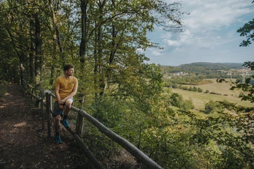
The view through the "forest window" at Kälberfels opens wide views over the Prims valley to the ridges of the Black Forest highlands.
In the valley of the Sollbach stands the natural monument "Five Oaks." The five oak trees, about 200 years old, grew from a single oak stump upwards. The Sollbach valley formed the border between the German Reich and the then "Saar territory," which was under the League of Nations at that time, between 1920 and 1935.
The longer you walk along the stream, the more path-like the way becomes, leading into complete seclusion. Above the Sollbach valley stands the "Three Circles Stone." Here the borders of the districts Merzig-Wadern, Saarlouis, and St. Wendel meet. Then the path continues upwards to the high plateau between the villages Vogelsbüsch and Altland.
In the Primstal, the path steeply ascends towards the nature reserve "Young Hirschkopf." Several bizarre rock spurs, known as the "Waderner layers," are passed. The path leads along the former railway embankment along the Prims back to Büschfeld.
The trail was rated with 72 experience points by the German Hiking Institute.
Good to know
Best to visit
Tour information
Loop Road
Loop Road
Stop at an Inn
Author
Frank Polotzek
Organization
Saarland
License (master data)

Nearby


Download GPX file