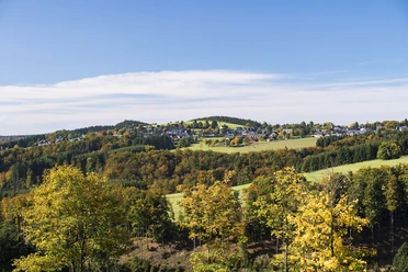
Experience mountain stream in the Renautal (As1) /Health climate tour 2

- 2:30 h
- 7.34 km
- 170 m
- 170 m
- 635 m
- 779 m
- 144 m
- Start: Haus des Gastes - Altastenberg
- Destination: Haus des Gastes - Altastenberg
Health-climatic route through a valley fed by mountain streams and inviting forest bathing
Beautiful, idyllic circuit which has been measured physiologically in terms of performance and bioclimatically:
Difficulty due to the path: MEDIUM
Medium-length circular route with descent into the Renautal and subsequent ascent back to Altastenberg with a total of about 170 meters of elevation. Average energy consumption for a 75 kg body weight: approx. 486 kcal.
Climate-related demands: LOW
Mainly subdued climate stimuli in the shelter of trees with some sun and wind exposure.
Good to know
Best to visit
suitable
Depends on weather
Tour information
Loop Road
Loop Road
Stop at an Inn
Author
Kristina Heimann
Organization
Ferienwelt Winterberg
License (master data)

Nearby

Download GPX file