Familientour - Abstecher ins Grüne


- 0:51 h
- 3.47 km
- 17 m
- 110 m
- 136 m
- 26 m
- Start: Information board Einbeck Ivenstraße, red sandstone bridge, information board
- Destination: Kuventhal playground
This short cycle tour (the same route there and back - 3.5 km each way) is perfect for families.
The idyllic tour is part of the well-signposted "Bridges and Borders" cycle path, whose route logo you can use as a guide (bridge with barrier).
If you need tips and more detailed information about the tour click on the author's tips and the route description below!
We hope you enjoy cycling!
Waypoints

Good to know
Best to visit
Directions
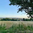
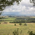
The gravel field path leads you past meadows and a small river, the Krummen Wasser. You cross this at two places over a bridge.
Trail information:
The stately lime tree at the Ohlehof is already over 300 years old and as a "teenager" could perhaps have been an eyewitness when Octavio Piccolomini's troops besieged the town towards the end of the 30 Years' War and set fire to the new town. With a circumference of over 6.5 m, it is probably one of the most valuable natural monuments in the Einbeck area.
At the "Krumme Wassermühle" farm on the left in the valley is a drinking water protection area, from which up to 30% of Einbeck's drinking water is extracted. Three wells here pump up to 60,000 liters of water per hour from a depth of around 50 m. As this is very hard, i.e. very calcareous water from the shell limestone, it is blended with the very soft Solling water, which is piped to Einbeck.
The Krumme Wasser, also known as the "Hille-Bach" in its upper reaches, has its source in the north in the forests of the Hils. After a course of 16 km, it flows into the Ilme south of Einbeck.
The Krumme Wasser played an important role in the creation and development of Einbeck: it supplied the town with much-needed water for the fortification ditches, the wells and the brewery. It was also decisive for the naming of the town. It was a village "An der Beke" (on the stream) and, according to surviving documents, it first became "Embeke" in the 11th century, "Einbike" in the 12th century and later "Einbeck".
Originally, the stream probably ran through the middle of the town, but was later routed past the western side of the wall.
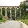
The village of Kuventhal is tightly squeezed into the 50 m deep valley incision of the stream. As can be seen from the two-tier bridge at the end of the village, the village has largely adapted to the natural shape of the valley. The local chronicles tell of frequent severe floods as a result of melting snow or torrential downpours. A flood in the summer of 1886 is said to have reached a height of 4 m in the village and caused severe damage.
Due to the naturally narrow valley, the stream swells very quickly and can burst its banks within a few hours. Unlike larger rivers, however, the floods are often short-lived.
Tour information
Familiy-Friendly
Directions & Parking facilities
You reach the starting point of the circular route from the market square via Tiedexer Straße in the direction of Tiedexer Tor. Ride past the Tiedexer Tor, past the PS.SPEICHER - the exhibition on the history, present and future of our individual mobility on wheels - and turn right into Ivenstraße after 300 meters. Another 100 meters and you have reached the old bridge.
The bridge made of red sandstone spans the Krumme Wasser on Ivenstraße and is a unique structure from the 16th century with its two pressed pointed arches. As part of the Einbeck-Alfeld-Hanover military road, it connected the southern German towns with the Hanseatic towns of the north 500 years ago.
After crossing the bridge, follow the cycle path for around 200 meters, cross the main road and follow Ivenstraße until you reach the riding and driving club. Here, the cycle path turns left into the Riesswarte. In the past, a lookout point was part of the outer defenses of a fortress or town. It often stood as a fortified tower far in advance of the actual fortification, so that the enemy could be spotted from it at an early stage. The warning time was shortened by signaling systems. Alongside the land defense towers, the tower was one of the three lookouts within the Einbeck area. The Middle High German noun "ris" means "rice, branch, bush, shrubbery ...".
Organization
Weserbergland Tourismus e.V.
License (master data)
Tourist-Information Einbeck

Author´s Tip / Recommendation of the author
Nearby
