Hiking route 'Soldanelle' (Snowbell) (Philippsreut - Finsterau - Lusen)


- 8:00 h
- 23.30 km
- 880 m
- 480 m
- Start: Hauptstraße, 94158 Philippsreut
- Destination: Lusen
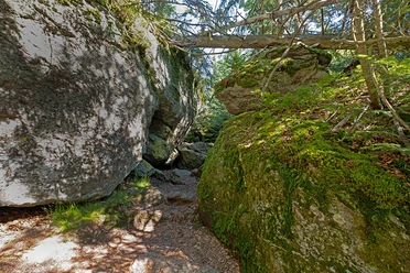
The 'Soldanelle' (Snowbell) hiking trail connects the municipality of Philippsreut with the National Park. It leads through the villages of Mitterfirmiansreut and Hinterfirmiansreut to the Hammerklause and further on to Finsterau. From there, the 'Soldanelle' (Snowbell) trail descends into the valley of the Reschbach before the varied ascent to Lusen begins. The trail follows along the Schwarzbach until it is crossed via stepping stones, reaching the Markfleckl at the German-Czech border. The last meters to the summit of Lusen lead over the impressive boulder field.
Good to know
Best to visit
suitable
Depends on weather
Contact person
Hans-Eisenmann-Haus
Nationalparkzentrum Lusen
Böhmstr. 35
94556 Neuschönau
Author
Nationalparkverwaltung Bayerischer Wald
Freyunger Str. 2
94481 Grafenau
Organization
Nationalparkverwaltung Bayerischer Wald
License (master data)

Nearby