


- 2:30 h
- 7.91 km
- 177 m
- 177 m
- 408 m
- 537 m
- 129 m
- Start: Holthausen - Gasthof Vollmer-König
- Destination: Holthausen - Gasthof Vollmer-König
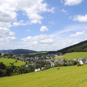
When purchasing the start card, you receive a route map with detailed directions. The route follows exclusively the excellently signposted hiking trail network of the Sauerländischer Gebirgsverein (SGV) in the Wanderwelt Schmallenberger Sauerland. You start in Holthausen at 490 m above sea level, going down to the lowest point of the hike at 407 m above sea level. We continue hiking through the gold village Niedersorpe and finally back to the starting point. Before reaching it, enjoy once more on an approximately 800 m long stretch a beautiful panoramic view over more than half of the P.W. "Wilzenberg" you have hiked, the core town Schmallenberg, wide parts of the Schmallenberger Sauerland, and our federal gold village Holthausen.
Happy hiking from the Wanderfreunde Holthausen-Huxel 1979 e.V.
Good to know
Best to visit
Directions
Foreword:
Our permanent hiking trail of 8 km and 16 km is not equipped with its own trail markers. Instead, we use the existing trail markers of the SGV and the distinctive hiking signposts of the Wanderwelt Schmallenberger Sauerland. They consist of a square wooden post with attached metal plates. At the bottom edge, the signposts are sometimes labeled with the location name but always carry the altitude in meters above sea level. We use these orientation aids for the current location determination. They are listed in the further route description as “Signpost location name” or “Signpost altitude.”
Route description 8 km:
We leave the starting inn and turn right, heading towards the bus stop. We follow the street out of the village. 50 m before the village exit sign we see on the right at the junction the first “Signpost Holthausen Cemetery.” Here we turn right and follow the hiking trail W2 towards Winkhausen. Upon arriving at the main road in Winkhausen, we walk along it for a bit towards the village until the road junction towards Niedersorpe. The path leads left towards Niedersorpe for about 170 m along the village street behind the Hotel Deimann. There we turn right off the road, walk past the pond, cross the stream, turn left and hike on the Sorpetalweg towards Niedersorpe along the stream to the “Signpost Niedersorpe Cemetery.”
Here we follow the hiking sign X13 through Niedersorpe to the Holthausen sports field. We continue with X13 uphill, turn around the barn and walk the short ascent (100 m) to the “Signpost 536 m.” From here we continue left with X13. After the barn located on the right along the path above Holthausen, we take the second turn left and go down into the village to our starting point.
Tour information
Loop Road
Stop at an Inn
Equipment
Directions & Parking facilities
Bus lines: 464, 462, and 474, stop Kirchstraße (Holthausen) Schmallenberg
Timetable information: www.rlg-online.de
Additional information
The hike can also be done as a 16 km long route. It leads over the Wilzenberg with its observation tower. From here you have a wonderful view over the Schmallenberger Sauerland up to the Kahlen Asten.
To the 16 km hike "Holy Mountain" Wilzenberg
The entry fee of 3 euros per participant includes the IVV stamp and insurance coverage.
The hiking trail is insured against third-party liability claims. Insurance coverage applies to the start and finish area and the specified hiking trail. There is accident insurance for participants. This insurance applies to accidents occurring during the hike on the designated trail, provided the participant holds a valid start card that bears the participant’s full address. Liability for accidents outside the designated trail is excluded. Start cards are available at the Landgasthof Vollmer-König (closed on Tuesdays).
Literature
Author
Wanderfreunde Holthausen-Huxel 1979 e. V.
Organization
Schmallenberger Sauerland Tourismus
License (master data)

Author´s Tip / Recommendation of the author
Safety guidelines
Map
Nearby
