


- 6:30 h
- 22.78 km
- 545 m
- 545 m
- 323 m
- 491 m
- 168 m
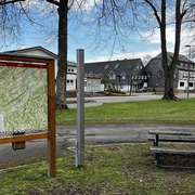
- Start: Reiste, parish church St. Pankratius, Mescheder Straße (B 55)
- Destination: Reiste, parish church St. Pankratius, Mescheder Straße (B 55)
You can optionally walk the route in two stages. The SGV department Reiste recommends starting with the longer southern route and then hiking the northern route.
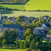
Chapels and wayside crosses are frequent companions on the paths in the community of Reiste. They testify to a deep religiosity practiced by the people here for centuries. Faith and prayer have always been part of everyday life. The bells of the houses of God marked the day, religious festivals the year. Wayside shrines or crosses were often erected out of gratitude or in memory of special events and have been cared for by local families up to today. Of course, each village has its own chapel and each is dedicated to a different patron saint.
The 22.6 km (25.7 km) long chapel route invites you to discover this tradition and the many beautiful chapels in the chapel villages around Reiste. Hike on secluded forest paths and discover the stories of the small houses of God. Along the way, impressive views will interrupt your hike, as will the many gems along the path framed by nature.
The chapel route gives you the opportunity to immerse yourself in the village structure of a long-established Sauerland community. You get an idea of what it was like to live "in the village," in reliable structures but also with some challenges. It was everyday life, even in the deep snowy winter, to manage the school route "over the mountain," or to walk to the Sunday church service in the next larger town, Reiste, in all weather. People kept contact between the larger and smaller villages. On all kinds of occasions, at festivals and celebrations, the footpaths were not shunned. Whether shooting festivals, harvest thanksgiving festivals or the traditional Reister market: people went to Reiste, celebrated together and enjoyed cozy hours. These encounters still exist today. However, today, on such occasions, many residents tend to walk back to their home village. On the one hand because of the beautiful nature, on the other hand probably also because of the occasional beer, which is better digested while walking…
Reiste and its chapel villages have preserved their lively club life to this day. Hike the chapel route and encounter a real piece of Sauerland with its traditions. Let yourself be inspired by nature on the way between the chapels and come to rest. Stop by in one or another chapel and hold a silent prayer. Or sit down on a bench on the way, enjoy nature or admire one of the little works of art along the path.
Good to know
Best to visit
Directions
Reiste – Niederreiste 1.4 km
The chapel route begins in Reiste at the parish church St. Pankratius. After you have crossed the B55 at the traffic light, walk past the former Protestant church out of the village and turn left. Above the sports field, hike towards Niederreiste. There you reach the first destination, the 14 Helpers Chapel.
Niederreiste – Beisinghausen 1.4 km
Next to the chapel, cross the B55 again and turn right onto the path. Continue hiking across the East Field towards Beisinghausen. Turn left and go up into the village. In the middle of the village is the St. Margaretha Chapel.
Beisinghausen – Landenbeck 4.7 km
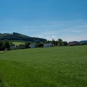
Passing the old smithy and the war memorial, the chapel route quickly gains altitude. You leave Beisinghausen behind and reach the Sauerland Höhenflug halfway up the mountain. Continue to follow it uphill to the “Sohl”. Here you then leave the Sauerland Höhenflug to the left. You continue hiking over the ridge and slightly downhill along the flank of the Landenbeck valley. Turning left again, walk through the forest into the village of Landenbeck. A little way down the village you will find the St. Barbara Chapel.
Landenbeck – Sögtrop 3.1 km
A little behind the chapel, the chapel route splits. From here you can take the loop via Sögtrop. Walk along the street through the village over the Hennebach. After the village, go up the hill towards Sögtrop. Continue hiking on the loop of the chapel route through the forest down into the Rarbach valley to Sögtrop. There you reach the St. Blasius Chapel.
Sögtrop – Herhagen 2.7 km
Now hike always along the Rarbach and later along the Henne to Herhagen. There you meet the main route of the chapel path again and can continue your hike on it. In the village you will find the St. Laurentius Chapel, which stands directly next to the birthplace of Christine Koch, known for her poems in Sauerland dialect.
Herhagen – Nichtinghausen 1.3 km
Now you leave Herhagen through the spacious valley of the Henne, which gives the Henne Reservoir its name. When you reach the first houses of Nichtinghausen, the St. Bernhard Chapel is not far away. At the bus stop in the village the B55 is crossed again. Here is another starting or stage point for the chapel route.
Nichtinghausen – Erflinghausen 2.5 km
Now hike a bit above Nichtinghausen at half height above the village. You meet the local hiking trail Re1 and follow it over the hilltop towards Erflinghausen. On the old funeral path you slowly descend into Erflinghausen, where you reach the hexagonal St. Lucia Chapel in the middle of the village.
Erflinghausen – Büenfeld 1.8 km
Behind Erflinghausen you slowly walk up to the high plateau near Büenfeld. Enjoy the beautiful panoramic view as the path leads you directly to the chapel "Maria Heimsuchung" in Büenfeld.
Büenfeld – Büemke 2.4 km
Follow the road in Büenfeld a bit through the village until the path lets you dive right into the gorge-like cut of the "Büenfelder Siepens". Here you pass the gem "die Holmke" and in the further course of the path you reach the Büemker valley. Continue hiking up into the village of Büemke and go to the St. Agatha Chapel.
Büemke – Reiste 4.4 km
You leave Büemke on the last section of the chapel route towards Reiste. Follow the path uphill onto the Reister mountain and further over its ridge. A good distance before the radio transmitter, turn right past the wayside cross. You are now walking on the old Büemker school path and descend into the Reister valley. Past the giant bench and the orchard meadow, you reach the village of Reiste shortly afterwards. After a last crossing of the B55 you are back at the starting point of the chapel route, at the parish church St. Pankratius.
There is a stamp passport for the chapel route, which can be stamped at the village chapels with a stamp of their respective patron saint. You can get the stamp passport at the entrance area of the Reiste parish church, in the inns of Reiste and Nichtinghausen, in the Volksbank in Reiste, at the grocery store as well as at the gas station in Nichtinghausen. The stamps are located in weatherproof boxes below the information boards of the individual chapels. Upon presentation of the fully completed stamp passport, you will receive a small souvenir at the above-mentioned issuing points (except parish church).
Tour information
Cultural Interesting
Loop Road
Equipment
Directions & Parking facilities
The church with parking facilities is located on federal highway 55, which runs through Reiste.
From the north: via the A46 to Meschede, then the B55 towards Olpe to Reiste.
From the south: via the A45 to Olpe, then the B55 via Grevenbrück, Eslohe towards Meschede to Reiste.
Parking spaces can be found at the parish church St. Pankratius Reiste.
You can park for free everywhere in Reiste. The SGV department Reiste recommends the parking lot at the parish church, which is directly at the starting point.
There is a direct connection by train from Dortmund or Kassel to Meschede, and from there with bus line S70 towards Grevenbrück, directly to Reiste.
There is a direct connection by train from Siegen or Hagen to Grevenbrück and from there with bus line S70 towards Meschede, directly to Reiste.
For timetable information: www.rlg-online.de
With the Schmallenberger Sauerland Card you travel for free by bus and train in the region.
Additional information
Literature
Author
SGV-Abteilung Reiste e. V.
Organization
Schmallenberger Sauerland Tourismus
License (master data)

Author´s Tip / Recommendation of the author
Safety guidelines
Map
Nearby