- Photos & Map
How would you like to arrive?
- Description
- Waypoints
- Good to know
- Nearby
Download GPX file
- 4:30 h
- 17.59 km
- 58 m
- 58 m
- 139 m
- 197 m
- 58 m
- Start: Preferably in Coswig-Spitzgrund/parking lot at the Spitzgrundteich or in Moritzburg at the castle parking lot.
The hike can be started in Coswig-Spitzgrund, or alternatively in Moritzburg.
This description starts in Coswig at the Spitzgrundteich pond. The route follows the valley path along the Lockwitzbach stream and the Spitzgrundteich pond to the historic Kreyern forester's lodge. From the chapel pond, you reach the picturesque Ilschenteich pond and arrive at the S81-Zugang/L-Weg junction.
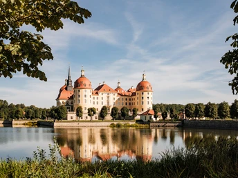
Here you can take the shortcut to the water lily pond. This shortens the circular walk to 9 km. The complete hiking trail leads via the Moritzburg district of Auer, the Münchhauwiese and the Steinernen Weg to Moritzburg Castle. Here you leave the Friedewald forest.
Via the center of Moritzburg, you reach Eisenberg, the founding village of the municipality of Moritzburg. Via the Luchsberg with its impressive views from Moritzburg Castle over the small hilltop landscape to the ridges of the Elbland, you return to the Friedewald.
In the St. Ulrich tunnel, you cross under the S81 state road and walk along the L-path and X-path in the direction of the water lily pond.
Both hiking tours now follow the same route again. From the picturesque water lily pond, take the forked path to the Hoher Stein viewpoint. After a magnificent view, the trail leads you back to the Spitzgrundteich, the starting point of the hike, via the Spitzgrundborn.
Start the hike from Moritzburg:
Start the hike from the castle parking lot in the direction of the historic Gasthof Adam. From Gasthof Adam, follow the signposts. Passing the town center, you will reach the village of Eisenberg, the founding village of the municipality of Moritzburg. You return to Friedewald via the Luchsberg with its impressive views from Moritzburg Castle over the small hilltop landscape to the ridges of the Dresden Elbland. In the St. Ulrich tunnel, you cross under the S81 state road. After approx. 500 meters you can shorten the circular walk to 9 km and return to the KARRAS circular route at the Ilschenteich pond, near the village of Auer, in the direction of Moritzburg.
The 17 km hiking route leads along the L-Weg and X-Weg in the direction of Coswig. From the picturesque water lily pond, you reach the Hoher Stein viewpoint via the Gabelweg. After a magnificent view as far as the Meißner Land, the hike takes you over the Spitzgrundborn to the Spitzgrundteich, the Coswig starting point of the hike.
Back to Moritzburg, you hike in the Spitzgrund along the Lockwitzbach stream and the Spitzgrundteich pond to the historic Kreyern forester's lodge. From the chapel pond, you reach the picturesque Ilschenteich pond. After a short distance, you cross two state roads at a junction with traffic lights. Passing the historic Gasthof Auer inn, you reach the Moritzburg district of Auer via the Siedlerweg. On the last part of the hike, the route takes you along the Münchhauwiese meadow to the Steinernen Weg. At the end of the Steinernen Weg, you will reach the Moritzburg castle pond and, after a short distance, the starting point of the hike.
Waypoints
Good to know
Best to visit
Tour information
Cultural Interesting
Loop Road
Stop at an Inn
Directions & Parking facilities
Coswig:
Approach via A4 - exit Dresden Neustadt, drive via Radebeul to Coswig
From the direction of Meißen via Dresdner Straße to Coswig
Moritzburg:
Approach via A4 from Dresden, exit Dresden-Wilder Mann
Coming from Berlin on the A13, take the Radeburg exit - drive to Moritzburg via Berbisdorf
Approach via the S179 from Dresden, the S81 from Weinböhla and Radeburger Straße from Radeburg
Public parking spaces are available at the starting points of the Karras circular trail.
Parking in Coswig-Spitzgrund/Spitzgrundteich is free of charge (hikers' parking lot).
Various paid parking spaces are available in Moritzburg, e.g. at Markttreff Moritzburg (castle parking lot).
Coswig:
by train:
S-Bahn 1 from Meißen and Dresden
RB 31 from Dresden and Elsterwerda
RE 15 from Hoyerswerda, Großenhain and Dresden,
RE 18 from Dresden and Cottbus
RE 50 from Dresden and Leipzig
by bus:
400 from Radebeul
401 from Meißen
405 from Radeburg
460 from Großenhain
Moritzburg:
by bus:
Bus stop Moritzburg, Schloss or Markt
Line +477 (FahrradBUS) from Radeburg, Großenhain and Dresden, between Dresden and Moritzburg every hour in the summer season with bicycle trailer,
Line 405 from Radeburg and Coswig
Line 458 from Großenhain
Bus line M (FahrradBUS, April to October)
by train:
Lößnitzgrundbahn from Radebeul-Ost or Radeburg, to Moritzburg, Bf
or from Dresden or Radebeul, Radeburg, Meißen with various bus connections.
Additional information
The flyer for the route is available from the Coswig Tourist Information Office and the Moritzburg Information Office. It can be viewed online here.
Author
Dresden Elbland Redaktion
Organization
Dresden Elbland
License (master data)
Author´s Tip / Recommendation of the author
Plan time to visit the Moritzburg hunting lodge.
Safety guidelines
A firm footing is essential for the trail. Telescopic poles are advisable. The route is not barrier-free and requires special attention in wet and stormy weather!
Nearby


