


- 6:53 h
- 21.57 km
- 773 m
- 751 m
- 111 m
- 278 m
- 167 m
On this hike, always follow the white in a circle on a black background:
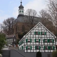
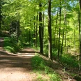
The first stage of the Klingenpfad trail takes you from Solingen Gräfrath across Gräfrather Heide, past the Fauna wildlife park and the Solingen Lichtturm down to Friedenstal on the river Wupper. Following the course of the river, the path then meanders through Kohlfurth towards Müngsten. Here the Klingenpfad leads over the Brückenpark in the direction of Burg. But before it reaches Unterburg, it winds its way up towards Rheinshagen and then trails off into the Eschbach valley. After crossing the valley floor, the Klingenpfad runs along Sellschaider Bach to Oberburg. This is where the first stage ends at the Talsperrenstraße car park.Tip: In Oberburg, you can visit Schloss Burg or enjoy a stop in one of the local restaurants or cafés. We can also recommend an overnight stay here.
The first stage of the Klingenpfad trail takes you from Solingen Gräfrath across Gräfrather Heide, past the Fauna wildlife park and the Solingen Lichtturm down to Friedenstal on the river Wupper. Following the course of the river, the path then meanders through Kohlfurth towards Müngsten. Here the Klingenpfad leads over the Brückenpark in the direction of Burg. But before it reaches Unterburg, it winds its way up towards Rheinshagen and then trails off into the Eschbach valley. After crossing the valley floor, the Klingenpfad runs along Sellschaider Bach to Oberburg. This is where the first stage ends at the Talsperrenstraße car park.
Good to know
Best to visit
suitable
Depends on weather
Tour information
Familiy-Friendly
Labelling
Stop at an Inn
Contact person
Klingenstadt Solingen
Ms. Sonja Nordmann
Cronenberger Straße 59/61
42651 Solingen
Author
Text: Lilian Möntmann, bearbeitet/übersetzt: Supertext/Home of Translation GmbH
Organization
Bergisches Land Tourismus Marketing e.V.
License (master data)
Text: Lilian Möntmann, bearbeitet/übersetzt: Supertext/Home of Translation GmbH

Nearby