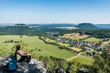
- Photos & Map
How would you like to arrive?
- Description
- Good to know
- Nearby
Download GPX file
- 2:30 h
- 6.37 km
- 378 m
- 378 m
- 113 m
- 312 m
- 199 m
- Start: Kurort Rathen station
- Destination: Kurort Rathen station
Spa town Rathen - Bastei bridge - Schwedenlöcher - Amselgrund - spa town Rathen
*
Good to know
Pavements
Best to visit
Directions
The hike starts at the station in the spa town Rathen. You cross the river by ferry (not part of the transport association, must be paid separately) and walk through the car-free town. Follow the signposts to the left towards Bastei. Now the route continuously ascends, keep left at the next fork (blue mark) and climb numerous stairs.
Don't miss the detour at the Tiedgestein. A first spectacular view into the Elbe valley. Back on the path, you climb more steps. Here there is another worthwhile detour to the Kanapee viewpoint.
Soon you pass through a rock gate that Caspar David Friedrich immortalized in one of his famous paintings. And you are already standing on the Bastei bridge built in 1851.
Directly after the Bastei bridge, you can go right to the Ferdinanda viewpoint before you reach the famous Bastei viewpoint on the left. After the 190 meters elevation difference, you are rewarded with a comprehensive panoramic view: At your feet the famous sandstone cliffs and on the horizon the table mountains south of the Elbe.
Then continue towards the buildings and follow the blue marking towards Schwedenlöcher. Right behind the Bastei hotel is another hidden viewpoint, the Wehlstein viewpoint. From here, follow the forest path initially parallel to the road and parking lots, before turning right to reach a resting place. Here the Pavillon viewpoint is recommended to enjoy a complete view of the Bastei before descending from the Bastei massif into the deep, wild gorge of the Schwedenlöcher.
After many stairs, you reach the Amselgrund. Once down, keep right (green mark) and pass the Amsel lake. Here you can rent a rowboat for a small fee. The path leads back to Rathen. In town, keep right and walk back to the ferry to get to the S-Bahn station on the other side of the Elbe.
Where do the Schwedenlöcher actually get their name?
The name goes back to the 17th century, specifically the time of the Thirty Years’ War (1618-1648), when the Swedes marched through the land. They had a reputation for robbing, destroying, and plundering everything. The then inhabitants of the adjacent villages brought their possessions—and themselves—to safety in the gorges or “holes.” The rugged rock formations offered many good hiding places. The adventurous but also romantic gorge leads us between moss-covered green walls and rough rocks over two steep iron ladders and about 700 steps down from the Gansweg to the Amselgrund.
Tour information
Loop Road
Stop at an Inn
Directions & Parking facilities
Paid parking lot at the ferry pier in the spa town Rathen, left bank of the Elbe.
S-Bahn to Kurort Rathen stop
Use this link for your arrival: https://www.vvo-online.de
During the hike you cross the Elbe by ferry, which is not part of the transport association. You can buy the ticket directly on the ferry for the return trip. Please also allow for waiting time at the ferry when planning your route.
Author
Yvonne Brückner / Tourismusverband Sächsische Schweiz e.V.
Organization
Tourismusverband Sächsische Schweiz
License (master data)
Author´s Tip / Recommendation of the author
Safety guidelines
The route is suitable for sure-footed children, but not for dogs.
Map
Product information "The Bastei"
Hiking map
Bastei - Spa town Rathen - town Wehlen - Uttewalde
Scale: 1 : 10,000
ISBN 978-3-910181-05-5
Publisher: Dr. Rolf Böhm Cartography
Buy here: Hiking maps
Nearby


