- 3:15 h
- 10.87 km
- 232 m
- 226 m
- 613 m
- 723 m
- 110 m
- Start: Jagdhaus town centre
- Destination: Jagdhaus town centre
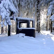
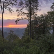
This route takes you in a loop, partly along the Rothaarsteig, through the forests of Jagdhaus. Around the Härdler, past the Margaretenstein and the Potsdamer Platz, it leads back to the starting point.
Good to know
Best to visit
Directions
Always follow the hiking sign J4.
Tour information
Loop Road
Equipment
We recommend sturdy footwear, as well as bringing enough food and drinks.
Directions & Parking facilities
Parking is available at the hiking parking lot in Jagdhaus.
The Ismo 466 bus line operates in Jagdhaus (former hiking bus, must be booked at least 30 minutes before departure).
Timetable information: www.bahn.de
With a valid Schmallenberger Sauerland Card, you can use public transport in the Hochsauerlandkreis for free.
Additional information
For dining after the route, the Hotel Jagdhaus-Wiese, the Schäferhof, and the Gasthaus Tröster are recommended.
Author
Schmallenberger Sauerland Tourismus e.V.
Organization
Schmallenberger Sauerland Tourismus
License (master data)

Safety guidelines
A rescue point system is installed in the Hochsauerlandkreis. You can find rescue points, among other places, on the information boards at junctions and on hiking signs.
Map
Hiking map Schmallenberg, scale: 1 : 25,000;
Hiking map Fleckenberg, Jagdhaus, Latrop, scale: 1 : 29,000
Nearby