


- 2:45 h
- 33.37 km
- 3 m
- 3 m
- 3 m
- 11 m
- 8 m
- Start: Tourist Info Aurich
- Destination: Tourist Info Aurich
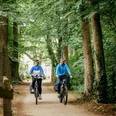
From the center of Aurich, the route leads north out of Aurich. It quickly becomes rural and goes on partly unpaved farm roads to the Aurich Tannenhausen district. The path passes directly by the beautiful bathing lake and leads towards the Ewiges Meer, the largest raised bog lake in Germany. Both unpaved and paved paths are available. Then it goes into the forest through a twisting trail. We change district towards Plaggenburg and find ourselves in the forest again. It goes along a rewetted moor area, the Plaggenburger Moorwald, then through the forest back towards Aurich. The forest only leaves us about 1 km before the city center.
Good to know
Best to visit
Tour information
Loop Road
Stop at an Inn
Directions & Parking facilities
Address:
Tourist Information / Aurich Tourist Association e.V.
Norderstraße 32
26603 Aurich
Organization
Ostfriesland Tourismus GmbH
License (master data)
Marco Bordasch

Author´s Tip / Recommendation of the author
Nearby