


- 2:27 h
- 9.62 km
- 124 m
- 124 m
- 85 m
- 132 m
- 47 m
- Start: Town hall in Rödinghausen (Amtshausstraße, Rödinghausen)
- Destination: Town hall in Rödinghausen (Amtshausstraße, Rödinghausen)
From Rödinghausen to Westkilver: "twas duüer"
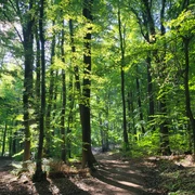
120 years ago, ordinary people walked! They often walked from church to church on crooked, uneven field paths when they wanted to go to the neighboring village. Two villages situated in a hilly landscape, in a typical East Westphalian landscape! And there is plenty of countryside between the church spires.
On the way, people met relatives, acquaintances and friends who were working in the fields and meadows. They would often have a quick chat first, certainly about the weather. Livestock often stood by the wayside, and it was not uncommon for goats to be tethered. Roadsides with lots of colorful wildflowers were not uncommon - on the way across, "twas duüer", as they say in Low German in Rödinghausen.If you are interested in more information, you can easily get it with your smartphone using the QR codes on the respective information boards.
Today, most people drive such a route by car in five minutes on paved roads.
Better set off on foot along the Patt (path), like people used to do! Because there are still living hedges, flowering orchards, ancient giant trees and much more to experience. So let's go: "lot us uppen Patt maken"!
The NABU also offers a map for download.
You can also find more information on the district's cycling leisure website Fahr-im-Kreis.de.
Waypoints
Good to know
Best to visit
Directions
The route starts at the parking lot behind the town hall in Rödinghausen. From there, it heads in a south-westerly direction parallel to the road. The road is then crossed before the Kilverbach stream and the path continues south along the hedge. The road Im Niederfeld is also crossed and the path continues diagonally to the left and through the ford at Kollbach. At the crossroads, which is located approx. 600 meters after the ford, the route continues to the right along the Benjeshecke hedge.
After another 500 meters, the route turns left and runs along the clay pit. At the junction of Am Freibad and Westkilverstraße, the route follows the latter past Haus Kilver and the natural monument of the oak tree on Westkilverstraße, continuing to the left past the orchard meadow. Approx. 300 meters after the orchard meadow, the route describes a branch path to the right to the Kollmühle and the state border and back again. After the short detour, the route continues along Westkilverstraße to reach St. Michael's Church in Westkilver. This can be used as an alternative start or finish point. Behind the church, Friedhofsweg turns off to the left and at the 2nd field path, the route continues left again to the junction of Buschweg and Im Felde. Continue straight ahead along this road to reach Luskampweg and then turn left again. After approx. 400 meters, the route leads back to the right along the familiar route. At the oak tree natural monument, follow Sachsenweg straight ahead this time, passing the valuable deadwood and the wet meadows and ponds until you reach Bünder Straße. After crossing the road, you will find Rödinghausen town hall to the east.
Tour information
Familiy-Friendly
Loop Road
Directions & Parking facilities
Additional information
Author
Thomas Wehrenberg
Organization
Touristikgemeinschaft Wittekindsland Herford e.V.
License (master data)

Author´s Tip / Recommendation of the author
There are 15 points of particular interest during the hike:
- Röddinghausen town hall
- Hedge
- Furt
- Benjes hedge
- Clay mining
- House Kilver
- Oak tree natural monument
- Meadow orchard
- Kilver stream valley
- Border with Kollmühle
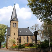
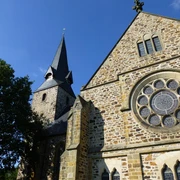
- Church of St. Michael in West Kilver
- Animals on the building
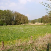
- Landscape near Westkilver
- Valuable deadwood
- Moist meadows, pond
You can find more information about these points on the information boards there.
Nearby