Natursteig Sieg | Etappe 07 | Herchen–Schladern

18.46 km long
Difficulty: difficult
Condition: very difficult
Hiking
  • 6:00 h
  • 18.46 km
  • 540 m
  • 502 m
  • 98 m
  • 264 m
  • 166 m
  • Start: train station Herchen
  • Destination: train station Schladern
Close to victory

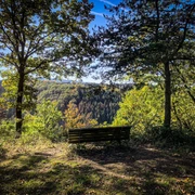
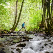
Detour into adventure: The seventh stage takes you over hill and dale on spectacular paths with wonderful views of the Sieg. How about ending at the Siegwasserfall?

Good to know

Best to visit

suitable
Depends on weather

Directions

At the beginning you hike the Philosopher's Path - a narrow path on the steep bank of the Sieg. A new forest is developing on the areas of the former spruce forest. On wider paths we then go up to a wide, partly wooded height and later steeply down again to Sieg. In narrow bends, almost 80 meters of altitude are overcome over a distance of around 200 m! The idyllic Siegau meadows around Hoppengarten border the hike. For a short time you have to separate yourself from the view of the river as you go up to the Auenberg. Then on narrow paths through deciduous forest down to Übersetzig and back to the Siegufer. Here a fantastic path winds gently up and down above the river and offers a touch of adventure. At the entrance to the town of Dreisel, the Sieg nature trail makes a long loop through a protected meadow valley and, after crossing the Sieg, climbs up through a sparse oak forest. It's not far to Altwindeck. The museum village and the impressive Windeck castle ruins want to be visited. It was tiring, but nice!


©W&A Marketing & Verlag GmbH

Equipment

Sturdy shoes and clothing appropriate for the weather

Directions & Parking facilities

A 560 towards Hennef, AS Hennef (Sieg) East – L 333 towards Eitorf, continue via Stromberg to Herchen.
P&R facility at Herchen (Sieg) station, Stromberger Straße 1, 51570 Windeck-Herchen.
Herchen station: RE 9, lines S12 and S19

current departure times for Herchen station


Schladern station: RE 9, lines S12 and S19

current departure times for Schladern station

Additional information

Stamp point: Natursteig refuge near Übersetzig

www.natursteig-sieg.de

Natursteig Sieg on Facebook


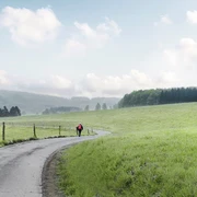
All stages of the Natursteig Sieg lead from station to station and are completely marked with the blue Natursteig Sieg logo in both directions. The access routes to the quality hosts, town centers and train stations are marked in yellow. You can find displays with overview maps and further information about places to stop for refreshments and overnight stays as well as sights at the train stations and at the starting points of the stages.

Literature

Author

Naturregion Sieg

Organization

Rhein-Sieg Tourismus

License (master data)

License: Attribution, ShareAlike

Author´s Tip / Recommendation of the author

Short detour to Dattenfeld and the Siegtaldom

Map

Nearby

Contact

Natursteig Sieg | Etappe 07 | Herchen–Schladern
51570 Windeck