Ralbitz-Rosenthal - Route 1


- 2:30 h
- 7.69 km
- 32 m
- 32 m
- 145 m
- 176 m
- 31 m
- Start: Pilgrimage Church Rosenthal, Am Marienbrunnen 9, 01920 Ralbitz-Rosenthal, OT Rosenthal
- Destination: Pilgrimage Church Rosenthal, Am Marienbrunnen 9, 01920 Ralbitz-Rosenthal, OT Rosenthal
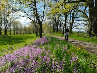
A pleasant half-day route through long pine forests and easily walkable field paths amidst the Sorbian settlement area.
The bilingual municipality of Ralbitz-Rosenthal is located in the core area of the Sorbian-speaking Lusatia. Many traditions and customs, especially Sorbian ones, are lovingly maintained in the villages.
In Rosenthal, there is a Marian pilgrimage site which was supervised by Cistercians until 2007. Several pilgrimages take place annually on the pilgrimage meadow, including those of the Diocese of Dresden-Meissen. The pilgrimage site Rosenthal is one of five pilgrimage places united in the association "Central European Pilgrimage Sites" since 2000.
Long coniferous and mixed forests, well-maintained paths, and pleasant rest areas at the many ponds of the region make the flatland hikes around the village relaxing experiences.
Good to know
Pavements
- Street (3%)Asphalt (12%)Gravel (21%)Trail (63%)Path (1%)
Best to visit
- suitableDepends on weather
Directions
The route description proceeds counterclockwise.
- The route begins in front of the pilgrimage church in Rosenthal.
- Past the church, continue to the festival meadow.
- Now the path leads for about 4 km through varied pine and birch forests.
- After crossing the S 97, about 500 meters ahead is the Piskowitz Stone Circle on the left side.
- At the Sand Pond there is a great picnic area which is equally suitable for wildlife observation (amphibians, birds).
- The first small village after the long green section is Dreihäuser (birthplace of the Sorbian writer Jurij Bresan).
- From here proceed along field paths to Zerna. (The local bus stop is set up as a book exchange and could also serve as a shelter if necessary).
- Finally, you return to Rosenthal.
- The path through the village passes along a playground and a few meters further on there is a small bakery.
- Finally, the path passes by the Marian spring (whose water is said to have healing effects) back to the starting point.
Tour information
Cultural Interesting
Loop Road
Suitable for Pushchair
Tour with Dog
Equipment
- Sturdy footwear
- weather-appropriate clothing
- binoculars
- provisions
- insect repellent spray
- overview map
- mobile phone with power bank
- first aid kit
- mushroom basket in autumn
Directions & Parking facilities
- Getting there
- Motorway A4 (between Bautzen and Dresden)
- Exit Uhyst am Taucher
- Turn towards Kamenz
- Stay on S101 for about 9 km
- Turn onto S97 towards Zerna (Kamenzer Straße)
- The next village is Rosenthal
- Turn into the village at the second opportunity (Am Marienbrunnen)
- The destination (pilgrimage church) is on the left (after 300 m)
ParkingPlease use the free parking options near the pilgrimage church.Public transportationPlease use the digital and therefore up-to-date timetable information of the Zweckverband Verkehrsverbund Oberlausitz-Niederschlesien (ZVON): www.zvon.de
Additional information
- Upper Lusatia: www.oberlausitz.com
- Upper Lusatian Heath and Pond Landscape: www.oberlausitz-heide.de
- Municipality Ralbitz-Rosenthal: www.ralbitz-rosenthal.de
- Tourist site about the Sorbs: www.tourismus-sorben.com
- Digital German/Sorbian Dictionary: www.soblex.de
Literature
Link to the online shop of the "Domowina-Verlag" Bautzen
Author
OHTL e.V.
Organization
Das Landschaftswunderland Oberlausitz
License (master data)
OHTL e.V.

Author´s Tip / Recommendation of the author
Due to patchy network coverage, it is recommended to download the route before starting.
Unfortunately, apart from the bakery in Rosenthal, there are no dining options, which is why we recommend the route as a picnic route. The rest area at the Sand Pond is excellently suited for this purpose.
Safety guidelines
Entering the forests is at your own risk - however, it is strongly advised against during strong wind and storms or snow and ice.
Hiking with caution - brochure from the German Hiking Association with tips for proper behavior when hiking around (wild) animals.
Map
- SACHSEN KARTOGRAPHIE GmbH Dresden: Leisure Map "Oberlausitz
- SACHSEN KARTOGRAPHIE GmbH Dresden: Cycling and hiking map "Oberlausitz Heath and Pond Landscape" (Sheet 1 and/or Sheet 2)
Both maps are also available in the online shop of the Oberlausitz-Neiderschlesien Marketing Company mbH.
Nearby


Download GPX file