Rocks.Mills.Gingerbread


- 4:00 h
- 11.12 km
- 123 m
- 123 m
- 162 m
- 203 m
- 41 m
- Start: Weichaer Hof, Hauptstraße 24, 02627 Weißenberg district Weicha
- Destination: Weichaer Hof, Hauptstraße 24, 02627 Weißenberg district Weicha
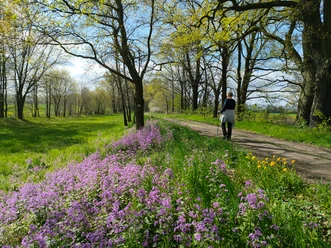
In the interplay of light and shadow, the Löbauer Wasser winds through the rock valley of the Gröditzer Skala. The kingfisher nests in its cave by the stream, bats dance in the moonlight at night, and the little wren greets the hikers from afar with a loud trill. The nature reserve between the towns of Weicha and Gröditz is one of the last witnesses of ice age changes in the region. With its rock formations, waters, and bright forests, the Skala offers a unique natural experience.
Above the Skala proudly towers in the west the "White Pearl", Schloss Gröditz. The elaborately restored castle park is of special regional historical value through the inclusion of an old Slavic fortification.
Long-dormant water mills surround the village of Gröditz. Along a disused railway line, a breathtaking view opens up to the hiker on a stone viaduct. In Weißenberg, the path leads to the "Old Gingerbread Bakery" museum.
Good to know
Pavements
Best to visit
Directions
The Gröditzer Skala, with its rock clefts, is a special gem in the rather gently rolling to hilly Upper Lusatian Heath and Pond Landscape.
- The route begins in the district of Weicha in the town of Weißenberg. Parking is available at the old park wall of the former manor house in Weicha.
The manor house was built around 1700 by the Polish noblewoman Anna Helena von Nimptsch. The manor house was built on the Weicha knight's estate, which had existed since the year 1241. However, it was only referred to as a knight's estate from the year 1563; before that, it was called a knight's seat. The manor house had various owners over time, including the families von Broizen and von Heynitz. During the National Socialist era, the estate was dissolved and transferred to several local farmers. After the end of World War II, a retirement home was established in the manor house, which operated until 2003. Today, the Weichaer Hof combines certified holiday apartments, an inclusion business, a restaurant, catering, riding lessons, and therapeutic practices. In the former manor house you can now find a vaulted cellar with a sun terrace. Additionally, halls can be rented. Events and festivals take place at irregular intervals.
The park is designed in the English style. An existing fortification was integrated into the ensemble. - Visitors turn back 100 meters toward the town exit (towards Weißenberg) until a path to the former Wuischke Mill (the ruin has been completely removed) turns left. Hikers follow this mill path about 400 meters to a junction that branches left into the Gröditzer Skala. The hiking trail marked with a yellow line leads directly downhill to the Löbauer Wasser.
The Gröditzer Skala is a breakthrough valley of the Löbauer Wasser, which has cut 30-40 meters deep into the quartz mica rocks of the Lusatian graywacke. The rocks are strongly metamorphosed and provide a good insight into the geological structure of this area. In the 19th century, the Weicha part was redesigned into a landscape park. In 1936, it came into the possession of the Saxon Homeland Protection Association. In 1938, it was declared the Gröditzer Skala Nature Reserve. In 1961, the entire Skala was designated as a valuable landscape area in Upper Lusatia. - At the bottom, the path leads over an interesting wooden bridge (cross at your own risk) to the right bank of the Löbauer Wasser. The path turns left towards Gröditz. The path is marked with a red line and the pilgrimage route symbol (symbol = shell).
- After a few hundred meters, the path forks. The path marked with a red line leads a short way out of the forest into the open landscape. Hikers use the pilgrimage route, which continues closely along the bank of the Löbauer Wasser.
- At the fork, follow the signs for Pilgrim Hostel & Guesthouse and head steeply uphill towards the "White Pearl", Schloss Gröditz. Hikers can get more information about the castle here.
Gröditz was first mentioned as a knight's estate in the 13th century. The castle founder in the year 1222 is considered to be Hans von Klüx. Over the centuries, the castle was expanded, altered, and repeatedly transferred to different owners.At the end of the 19th century, the von Krauss family acquired the lands and the castle. However, they were expropriated at the end of the war in 1945. Since 1949, it served, among other things, as a tuberculosis sanatorium.
In 2006, Beat von Zenker zu Pommritz, great-nephew of Gerda von Krauss, acquired the property. The support association "Pro Gröditz" was founded, and together with many members, an unprecedented reconstruction effort began to preserve the castle and the entire ensemble and to return it to a monument conservation unit.
In the baroque 3-story castle, which runs directly on the steeply sloping high bank of the Löbauer Wasser, the rooms were furnished with historic furniture. Stucco work, new floorboards, windows, and doors now let the halls shine in new splendor. The "Blue Salon" today also serves as a branch office of the Weißenberg registry office, and celebrations for about 70 people can take place in the "Large Garden Hall." The park invites with old trees, an orchard meadow, many places with benches, beautifully laid out rose beds, and many details to an extensive walk.
The idea of the pilgrim hostel on the grounds of the former Gröditz knight's estate was born in 2005 between then Superintendent Pappai and Mr. Beat v. Zenker. The former laundry house from 1954 was suitable for this. After dismantling non-listed rows of houses, the laundry house had to be completely renovated with great effort. Old element parts, such as today's entrance portal, were saved in the process.
The pilgrim hostel "Sante Martha" is now under the patronage of the Swiss Johanniter and offers year-round accommodation. Then the path "Am Schloss" passes a covered rest pavilion. At the next fork, the path "Alter Berg" leads left downhill.
- At the bottom, turn right onto "An der Skala" and after a few meters immediately left onto "Neue Straße".
- At the main road "Neue Straße," hikers turn left and follow the street over a steel bridge across the Löbauer Wasser. About 200 meters after the bridge, the signpost leads left towards a farmstead, but hikers walk directly right up a meadow slope (along the railing) and turn left behind the spruces.
- After some time, the path splits into an upper and a lower path; the route follows the "Upper Path," which partly strongly resembles a treetop path.
- After about 20 minutes, hikers reach the wooden bridge crossing the Löbauer Wasser. Here there is the possibility to shorten the route and return uphill to Weicha, the starting point of the route.
- The long route now runs in the other direction towards Weißenberg. Hikers cross the wooden bridge again and this time turn right towards Wuischke. The path is marked with a yellow dot.
The second part of the route is dedicated to the historic economy of the region. The milling trade had a great tradition in the area around Löbauer Wasser. Today, one can only imagine the importance the Weißenberg area had for supplying the entire region. Numerous water and windmills lie along the approximately 30 km long mill path, of which the route only follows a small part. - After about 5-10 minutes, the path turns left uphill at a red railing and now follows the disused railway line between Radibor and Weißenberg via a viaduct about 150 meters high towards the gingerbread town. On the left are the remains of the old Wuischke Mill.
- About 150 meters after the viaduct, you leave the railway embankment and follow the path "Zur Wuischker Mühle" eastward (away from the Skala). Past the wasteland of the Wuischke Mill, at the end of the path you change right onto "Wuischker Straße" towards Weißenberg.
- At its end, turn right again onto "Straße und der Einheit" and arrive directly at the Weißenberg marketplace.
In the town of Weißenberg, a visit to the Alten Pfefferkuchen Museum is definitely worthwhile. The museum is considered the only European monument used as a museum of the gingerbread craft and offers coffee and homemade pastries all year round.
The gingerbread craft has existed in Weißenberg for 370 years. After the Swedish invasion in the Thirty Years' War, all of Weißenberg burned down. The Alte Pfefferkuchlerei was rebuilt in the half-timbered style and is located directly on the marketplace today. It was awarded the "Europa Nostra" prize in 1992 for exemplary monument preservation restoration.
At the side entrance of the town hall you can find a public toilet.
Additionally, the Toro restaurant and the Kebab House offer options for refreshments. - From the marketplace, turning left, walk about 80 meters on Breitscheidstraße, then switch for about 50 meters to Berggasse, and then return to Breitscheidstraße, which becomes Bahnhofstraße after a few meters.
- Shortly afterward, on the right appears the hotel and guesthouse "Zum Bahnhof," where visitors have another opportunity for refreshments.
- Behind the hotel, after 50 meters, the path "Industriestraße" with the red line leads right back into the district of Weicha.
- At the junction to the railway embankment, visitors now keep left and follow the Sorbian Impressions cycle path back to Weicha.
On the way back to Weicha, there is again a view of the impressive viaduct of the railway line between Radibor and Weißenberg. It was built between 1902-1903. It consists of concrete and has 11 arches. Its length is 169.9 m. It has a height of 18.5 m and a width of 4.0 m. The arch radius measures 500 m. Shortly before the end of the war, in May 1945, it was partially blown up. It was rebuilt after the war. - After about ten minutes, hikers reach the starting point of the route at the Weichaer Hof.
Tour information
Loop Road
Stop at an Inn
Equipment
- Sturdy footwear
- Mosquito spray
- Power bank
- Drinks and provisions
Directions & Parking facilities
Motorway A4 exit Weißenberg - district Weicha
Free of charge at the Weichaer Hof
Additional information
Please inquire about opening hours, prices, and further details directly from the provider before your hike:
Weichaer Hof (Hauptstraße 24, 02627 Weißenberg district Weicha, Tel. 035876 46520)
Pro Gröditz (Am Schloss 12, 02627 Weißenberg district Gröditz, Tel. 0174 6680077 or pro.groeditz@web.de)
Museum Alte Pfefferkuchlerei (Markt 3, 02627 Weißenberg, Tel. 035876 40429)
Restaurant Toro Weißenberg (August-Bebel-Platz 13, 02627 Weißenberg, Tel. 0159 054 296 16)
Literature
Brochure "On discovery tour in the Upper Lusatian Heath and Pond Landscape" (Sorbian: Na slědźerskej turje přez kónčinu Hornjołužiska hola a haty) and online at www.oberlausitz-heide.de
Author
OHTL e.V.
Organization
Das Landschaftswunderland Oberlausitz
License (master data)
OHTL e.V.

Author´s Tip / Recommendation of the author
- A visit to the "Alte Pfefferkuchlerei" museum
- Picnic outdoors
Safety guidelines
- In rain and snowfall, increased risk of danger can be expected on the banks of the Löbauer Wasser. It is recommended to only walk the route in the months from April to October and generally not after heavy rainfall.
- The route is not barrier-free. (Strollers, wheelchairs)
- Due to patchy network coverage, it is recommended to download the route before starting.
Map
Various map materials for the Upper Lusatian Heath and Pond Landscape are available in the online shop of the Marketing Society Upper Lusatia-Lower Silesia GmbH.
Nearby


Download GPX file