


- 19:20 h
- 71.67 km
- 1,448 m
- 1,448 m
- 223 m
- 656 m
- 433 m
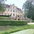
- Start: Dillenburg
- Destination: Dillenburg
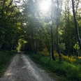
The route starts in Dillenburg. Here, the Westerwald and Dill variants of the Rothaarsteig separate. You decide on the Westerwald variant and follow the signs towards Fuchskaute. Above Donsbach, the Rothaarsteig leads you to Kornberg (453 m), rewarding you with a wonderful panorama. Following the Alten Rheinstraße, the Rothaarsteig meets the “Wildweiberhäuschen,” a 40 m high rock wall that rises vertically just a few meters from the Aubach. Along the Aubach, the Rothaarsteig then climbs uphill to Rabenscheid. Soon after, the path passes near the “Dreiländereck,” where North Rhine-Westphalia, Hesse, and Rhineland-Palatinate share a common border point. Now it’s about 4 km until the Rothaarsteig reaches Fuchskaute (657 m). Fuchskaute, a large nature and bird sanctuary, is the highest mountain in the Westerwald and at the same time the point where two Top Trails of Germany meet. Here, Rothaarsteig and Westerwaldsteig intersect.
Shortly before Weißenberg, the Rothaarsteig reaches the natural monument Ketzerstein (612 m) – the visible remainder of a basalt lava flow. If you happen to have a compass with you, its needle will probably behave erratically at this spot due to magnetic interference. From Ketzerstein, you have a beautiful view over the High Westerwald. The elevated villages Weißenberg and Liebenscheid are the next stops, followed by the ascent to Siegerland Airport. At the start of the Höh – a ridge rising up to 598 m above sea level – you reach the village of Lützeln. While the highest peak of the Höh remained unnamed, two smaller mountains were memorably named: Großer Stein (546 m) is actually lower than Kleiner Stein (587 m), which apparently has nothing to do with height but with its extent. Großer Stein is a conical mountain top with an area of volcanic rock blocks solidified into boulders. These basalt blocks are often covered with rare mosses and lichens. Hiking through open landscapes, you pass through the village of Würgendorf and then reach Kalteiche, where the Westerwald variant of the Rothaarsteig reunites with the main trail. On the main trail, the so-called Dill variant, you now head southeast towards Dillenburg. On your way, you will pass the Lucas Oak. This impressive tree is at least 230 years old. You leave behind Rodenbach and Manderbach and return to the Orange city of Dillenburg.

Waypoints

Good to know
Best to visit
Tour information
Loop Road
Loop Road
Stop at an Inn
Summit
Author
Harald Knoche
Organization
Touristikverband Siegen-Wittgenstein e.V.
License (master data)

Nearby
