- 4:45 h
- 13.90 km
- 177 m
- 169 m
- 142 m
- 223 m
- 81 m
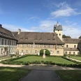
- Start: Rheder
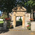
The circular hiking trail no. 2 starts in front of St Catherine's parish church in Rheder. Take the opportunity to take a quick look inside the church. Then walk along the road towards the castle, pass through the gateway of Rheder Castle and take in the view of the breathtakingly beautiful castle and the unique inner courtyard.
You now enter the Sieseberg Nature Park and immediately have a magnificent view of the wide landscape park, through which the Nethe flows. The west side of the castle and parts of the lower village with the church are now in your field of vision. The main design feature of the landscape park to this day is a visual axis known as the "Pückler-Schlag", which stretches from the central garden hall of the palace to the heights of the steeply rising wooded Sieseberg.
A preserved feature of the park is the temple on a hill at the entrance. In the immediate vicinity of the "Pückler-Schlag" on about half of the rising forest is the hereditary burial place of the current owner family Spiegel von Peckelsheim under a copper beech, which can be reached several times via a separate access path and several natural stone steps.
Further along the path, you will pass the castle pond, which is fed by underground water from the millrace in the Baroque style.
You walk through the landscape park directly at the foot of the Sieseberg with its rich population of old giant trees and pass another pond, the Rohrteich or Riedteich, which is fed by the inflow from the castle pond, but also by real spring water from the Sieseberg. From here, you should take another look back at the castle and pay full attention to the extensive landscaping. This meadow landscape is particularly charming in spring, when meadow foamwort, larkspur and wild garlic are in full bloom.
The landscape park and the extensive protected area of the Sieseberg are home to other botanical rarities. For example, the March cicely is still one of the early bloomers that is spreading over a large area.
After leaving the park through the gate pillar, turn left immediately and continue along the path used by forestry and agriculture, which leads you between the "Mähne" woodland and the agricultural "Dollenkamp" up a slight incline to the start of the "Sünderholz". Both woodland areas belong to the property of Count Sierstorpff, Bad Driburg.
Shortly after passing the spruce grove on the field side, you reach the connecting path from Siddessen to Schmechten or Istrup. Here, it is worth taking a look at the Brakel valley basin, the high-lying fields and the extensive forest steps of the Lippisches Bergland and the neighbouring Weserbergland. Even the Köterberg can be seen from here on a clear day.
A little further straight ahead, you come to the right-angled bend in the path to Schmechten and Istrup. Here the terrain reaches an altitude of approx. 225 metres. However, you continue straight ahead on the constantly sloping path through the Sünderholz and finally cross the K 20, which connects Gehrden and Schmechten. Turn half-left here and follow the steadily ascending forest path parallel to the district road through the "Mittelholz", past the "Eichental" refuge and the shooting range in the direction of the Gehrden sports field, which is located in front of the Gehrden holiday village. Here you will encounter the fruit tree nature trail for the first time, which was established in 1995. 54 different types of fruit have been planted here, some of which are typical of the area, such as the "Brakel apple".
You will pass the Hudewald forest, which used to serve as a communal meadow where small farmers and local residents could graze up to three head of cattle. The Hudewald was planted in 1997 in accordance with historical guidelines under the auspices of the Gehrden local history and tourism association. The 52 remaining oak trees, all of which are natural monuments, have been supplemented by 103 new plantings.
You reach the northern edge of the Gehrden holiday village via the sports field and come across the fruit tree nature trail again, from where you have an exceptional view of the Hudewald forest.
Following the road straight ahead, you reach the Rotheweg, which leads into the village to the right. Downhill, past the baroque wayside shrine "Christus am Ölberg", built in 1708, you reach the Öse. This small river crosses the municipality of Gehrden and flows into the Nethe at Siddessen. You follow the course of the Öse along the educational water trail set up by the sport fishing association. Numerous information boards provide information about the local wildlife in and along the course of the stream. Passing the former monastery mill from 1708, you reach a wayside shrine from 1701 with the image of a Pieta.
After this, turn right into the centre of the village on Hansaplatz square. You should not miss out on a visit to the historic village centre. A short walk will take you to Gehrden Castle, which was a Benedictine convent until secularisation in 1810. Today it houses a hotel. The former monastery church of St Peter and Paul, built in the 12th century and now Gehrden's parish church, is a gem of the highest order. Romanesque architecture and baroque furnishings form a unique synthesis. It not only houses a wealth of art treasures, but also a historically unique bell system consisting of nine bells. The former monastery district is also home to the Apostle's lime tree, which is said to be the third oldest lime tree in Germany. Experts do not agree on its exact age.
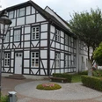
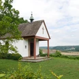
Before you return to Hansaplatz, you should take a look at the former town hall and other half-timbered buildings worth seeing. You pass the Bürgerhalle and continue your walk from Hansaplatz towards the Ösebrücke bridge, which is adorned with a statue of St Nepomuk. Turning left into the street "Am Ring", you now have to hike up the steadily ascending "Rosenberg", which is probably familiar to many people from the annual procession of the cross on Good Friday. Stone statues, which were donated by Gehrden families after the First World War in memory of their fallen sons, accompany you to your destination in the form of a stone high cross on the hill. Here you will also find St Catherine's Chapel from 1668 and a double-sided baroque wayside shrine with a legendary depiction of the life of St Catherine.
From this vantage point, hikers can look around for a while. Rewarding views in all directions: to the west the Eggegebirge mountains, the villages of Altenheerse and Drinenberg, to the east a partial view of Siddessen and a magnificent view to the east, e.g. of the radar station near Auenhausen.
You continue your hike on the left side of the high cross through a pasture belonging to the municipality of Gehrden, where you meet another section of the fruit tree nature trail. At the end of the pasture, the path on the left leads you along the tarmac path, which leads downhill at an acute angle onto the path through the beautiful deep valley to Siddessen.
Before you continue your hike, you can take a look at the sights of Siddessen. The oldest monument, the baroque portal of the former chapel from 1668, stands at the south-eastern entrance to the church square and is adorned with the coat of arms of Bishop Ferdinand von Fürstenberg. Today's church, a neo-Gothic building from the beginning of the 20th century, several houses and courtyards worth seeing with house inscriptions, the water courtyard and two Baroque wayside shrines with the images of St. Anthony and St. Apollonia are among the sights in the village.
Just a few metres east of the church, you reach the start of the "Klinkenhahn", a path that initially runs parallel to the Öse on the mountainside. After a few hundred metres, the Öse flows into the Nethe in the valley depression, which now flows on the right-hand side below the hiking trail. This section of the hiking trail has recently been converted into a cycle path and crosses the Nethe over a new bridge and then runs parallel to the B 252 towards Rheder.
You stay on the slightly elevated forest path, which leads you parallel to the course of the Nethe, back through the Sieseberg nature reserve until you reach the flood barrier, which diverts part of the Nethe water for the millrace described above. Follow a narrow footpath down the small hill to the footbridge over the Mühlengraben and cross the weir bridge to take a look at the "fish ladder" built in 2000, or more precisely the "meander pass". From here, you can see the full expanse of the Nethe valley running north-south. The "Spiegelbreite" on the other side of the Nethe valley can also be clearly seen from here.
You now return to Rheder via the "Philosophenweg", which is the official name of the embankment between the Nethe and Mühlengraben. As far as the fauna here is concerned, it should not go unmentioned that both the dipper and the kingfisher are permanent residents of this area. You will also pass artificially created ponds that belong to the biological sewage treatment plant of the von Mengersen steam brewery. With a constant supply of oxygen through a movable hose system into the slightly polluted water, the dirty water introduced into the plant is naturally purified from pond to pond.
After a few more steps, you will see the confluence of the Sieksbach and the Nethe. It has made its way from the Hampenhausen springs through the scenic and remote Rheder'sche Siektal valley, known as the "Himmelreich".
You can return to the village and your starting point at the church via the park path, which you have already got to know at the beginning of your circular walk, or via the alternative route mentioned at the beginning over the "Katharinabrücke" bridge.
Different paths/shortcuts are not maintained by the town of Brakel.
Waypoints
Good to know
Pavements
Best to visit
Directions
Tour information
Familiy-Friendly
Loop Road
Stop at an Inn
Tour with Dog
Equipment
Directions & Parking facilities
Additional information
Tourist Information, Am Markt 5, 33034 Brakel / Telephone no. 05272 - 360 - 1250
Contact person
Tourist Information Brakel
Author
Tourist Information Brakel
Organization
License (master data)
Tourist Information Brakel

Safety guidelines
Map
Nearby