


- 6:45 h
- 19.42 km
- 365 m
- 366 m
- 119 m
- 275 m
- 156 m
- Start: Brakel, parking lot at Bredenweg
- Destination: Brakel, parking lot at Bredenweg
From the car park on Bredenweg, the path leads over the Brucht millrace and along the old city wall (north wall). The "Königstraßertor" gate stood where the wall ends until the beginning of the 19th century. The bridge leads over the moat to the rampart, the so-called "Schmiedewall" between the "Königstraßertor" and the "Ostheimertor". The name of this preserved section of the rampart comes from the old smithy, which stands at the entrance to the rampart and was built on the remains of the front gate. A drawbridge led from the front gate on the rampart over the moat to the actual city gate.
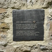
Walking over the rampart and looking at the houses on the east wall, it becomes clear that the expansion of the town in the 14th century as a result of the desertification process in the surrounding area took place in the floodplain of the Bruchtaue. The moat and rampart are therefore hydraulic engineering structures that are still intended to keep the floods away from the new town, which was first documented in 1383. This is why the rampart and moat have only been preserved on the eastern side of the town.The path leads up the Hembser Berg via the district holiday road. To the left is the town hall, inaugurated on 26 May 1926 and extended and modernised in the 1980s.About halfway up Hembser Berg, the cemetery of the town's former Jewish community is located on the left. The memorial plaque with the names of the Jewish citizens who perished during the Nazi era was unveiled in December 1989. The cemetery was a burial ground for 95 years (1854-1949). It contains around 230 graves that were destroyed during the Nazi era. After the war, the cemetery was restored to a dignified condition. It is the only reminder of the former Jewish community.
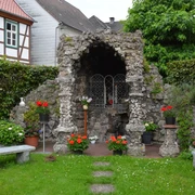
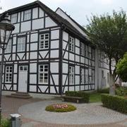
From the top of the Hembser Berg, there is a good view of the town of Brakel. The simple cross chapel on Hembser Berg was rebuilt in 1961 on a private initiative using gravestones from abandoned graves in the local cemetery. It is the successor to a chapel of which only small remains were left at the end of the 19th century.On the way eastwards, the view glides into the Nethe valley, which is bordered by heights of around 300 metres in the north and 250 metres in the south. To the east of Ottbergen, the Nethe valley widens into a funnel shape and offers a view of the Solling, which borders the landscape like a backdrop.Immediately, the view falls on two villages with different structures, Hembsen with around 1,100 inhabitants, the largest district of the town of Brakel, and Beller with around 250 inhabitants, the fourth smallest village among the town's districts.In Hembsen, the hiking trail meets the main street of the village. This is where the former Gunst farm is located. The manor house from the late 18th century can be seen through the gateway. It is a two-storey, plastered quarry stone building with a high cellar base and a high mansard roof.
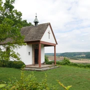
The current church, dedicated to St John the Baptist, was only completed in 1840 after 12 years of construction, as the marshy ground made it necessary to build on stilts. The church houses a wooden carved altar with a pillar structure and figures depicting saints of the Benedictine order. It is said to originate from the church of the former Benedictine convent of Brenkhausen.
Beller is a typical street village that stretches along the Nethe millrace. The origins of this settlement date back to the time of the Saxon land conquest. As early as the 9th century, it belonged to the possessions of the Corvey monastery. The wooded hilltop of Bellerburg Castle to the east of the village (249 metres) was the site of a castle belonging to the Corvey abbot in the Middle Ages. From the 14th century, the Asseburger von der Hinnenburg had extensive rights in the village through jurisdiction and entitlement to levies. In 1827, the Asseburger sold the western part of the Bellerburg (187 acres) to the municipality of Beller for 310 thalers.From Hembsen, the path leads up the Holzberg to the village's former communal forest on the Imberg. The Hembsen community forest, which has been part of the Brakel municipal forest since 1970, was previously owned by the von Asseburg, Haxthausen and Kanne families. In 1840/41, this forest became the property of the timber-entitled households in Hembsen through a recession.
From the top of the Imberg, the highest point of the hiking trail in the upper shell limestone, there is a comprehensive view. Three landscapes typical of the Brakeler Bergland can be recognised: the broad valley basin with the town of Brakel, the Nethe river valley between Hembsen and Erkeln and the extensive mountain plateau of the Hegge to the south with the dome of the radar facility (318 m).The view to the north-west goes over the Bökerhof with the lime tree avenue, sweeps over the Abbenburg estate to the so-called Lippische Wald, in front of which the Stoppelberg arches like a hump. The plateau of the lower shell limestone (approx. 200 m), one of the agricultural "favourites" since time immemorial, stretches directly towards Brakel at the hiker's feet. This is why there is no forest on this extensive arable land. In the Middle Ages, this Brakel field was protected by a land defence system. The Modex defence tower, first mentioned in a document in 1383, is a reminder of this to this day. Surrounded by trees, it stands out from the area.
The path continues along the edge of the forest. Until 1965, the Hembs municipal pasture was located where the forest now grows. Around 100 animals, cattle and cows, grazed there in return for a rent paid into the municipal coffers. In addition to farmers who herded cattle, it was the so-called "little people" who kept a cow there in the summer and thus had milk and butter for their livelihood. As the economic situation improved from the early 1960s onwards, the need and interest in keeping cattle on the pasture disappeared and the pasture was afforested in 1965. The old Hudebuche beech tree (known in Hembsen as the "Wilhelm-Winter-Buche"), which stands around 100 metres into the forest and provides an opportunity to rest, is a reminder of the pasture.Continue along the edge of the forest and down through the former Hembsen municipal forest to the Schleeberg refuge.The hiking trail crosses the district road at Schwarzes Kreuz and follows the Egge-Weser-Weg from Höxter to Bad Driburg. It runs along the western edge of Brakel's Modexen municipal forest, the former monastery forest of the Benedictine nuns of Brenkhausen. It was leased by the town of Brakel from 1531 and became its property around 200 years ago.
Behind the municipal forester's lodge, the view falls into a wide valley, the centre of which is the Hainhausen estate. Hainhausen is mentioned as a "villa" (= village) at the beginning of the 1st century. The Heerse convent and the monasteries of Brenkhausen and Corvey had rights in this "villa". After many changes of ownership, the estate, a settlement element in the area of former deserted settlements, was acquired by the Count of Asseburg in 1812 and a manor house in the Italian country house style was built The scattered settlement that characterises the landscape today was created around 1950. In accordance with the Refugee Settlement Act of 1949, land was given up by the nobility so that the state could settle farmers who had been displaced from the East in particular.The path follows the district road to a group of oak trees on the left. This is where the "Black Bridge" is located. The walls built from hewn stone are a reminder of the lawsuit between the town of Brakel and the Count of Bocholtz-Asseburg, which was brought before the Hamm Higher Regional Court between 1882 and 1886. The latter had had a bridge built over the then Bökendorf-Hembsen municipal road with a clearance height of 4.20 metres, as he wanted to be able to drive from Hinnenburg Castle to Hainhausen Castle exclusively over count's property. Following a judgement by the Hamm Higher Regional Court, the town's order to demolish the bridge was declared lawful because a "highly loaded harvest vehicle" could not be hindered.
The path now runs first between fields, then along the edge of the Hinnenburg Forest to the "Cemetery of Honour". Since September 1954, the remains of the German soldiers who lost their lives between the Egge and Weser rivers in March 1945 in battle with the advancing American troops on the Weser have rested there. (Information can be found at the entrance to the cemetery.)
The path continues through the Kaiser-Wilhelm-Hain. The area, once a pasture and now a park with a system of footpaths, owes its name to the decision of the Brakel town councillors in April 1913 to transform the municipal property, which covers around 13 hectares, "into a monument to nature" and name it "Kaiser-Wilhelm-Hain" in memory of the glorious 25-year reign of Kaiser Wilhelm II. This is part of the spa area of the town of Brakel, which was recognised as a climatic health resort in 1974. The centrepiece of the spa area is the mineral spring, a carbonated ferric acidulous spring, which is used by locals and guests and, according to the Judication, has healing effects on anaemia, urinary tract diseases and stone ailments. The fountain house and the Wandelhalle, built in the early 1960s according to plans by architect Allerkamp, is now a listed building.
On the spa path past the large pond complex, which was created in the early 1970s, and through the wide floodplain of the Brucht, you return to the starting point, the car park on Bredenweg.A section of this trail is designated as the Kaiserbrunnen/Modexen nature trail.
Deviating paths/shortcuts are not maintained by the town of Brakel.
Waypoints
Good to know
Best to visit
Directions
From the parking lot on Bredenweg, the path leads over the Brucht millrace and then along the old city wall (north wall). The bridge leads over the moat to the rampart. Walk over this rampart, turn left at the end and cross the Kreisferienstraße.
Now the path leads you up the Hembser Berg and to Hembsen. In Hembsen, walk to the main road, turn left there, walk to Landwehrstraße, turn left again and walk along the K 39. Shortly after the bridge, turn right onto a field path, up the Holzberg, onto the Imberg. At the edge of the forest, the trail continues through the former Hembs municipal forest down to the Schleeberg refuge.
The hiking trail crosses the district road at the Schwarzes Kreuz and follows the Egge-Weser-Weg from Höxter to Bad Driburg. Behind the municipal forester's lodge, the view falls into a wide valley with the Hainhausen estate at its center. Walk past the forester's lodge and turn left if possible. This will take you through Hainhausen to the district road K 39.
The path follows the district road until you reach a group of oak trees on the left. This is where you will find the "Black Bridge" (walls built from hewn stone). Cross the road and follow the path first between fields, then along the edge of the Hinnenburg Forest to the "Ehrenfriedhof" cemetery.
The path continues through the Kaiser-Wilhelm-Hain. Follow the spa path past the large pond and through the wide floodplain of the Brucht river back to the starting point, the parking lot on Bredenweg.Tour information
Loop Road
Stop at an Inn
Equipment
Directions & Parking facilities
From Paderborn via the B 64 federal highway to the Brakel junction
Ostwestfalenstraße 252 coming from Lemgo take the 1st exit, coming from Warburg take the 3rd exit Brakel. Follow Nieheimer Straße until the 1st junction, then turn left onto Bredenweg. The parking lot is on the left side.
Additional information
www.brakel.de
tourist-info@brakel.de
Tourist Information, Am Markt 5, 33034 Brakel / Telephone no. 05272 - 360 - 1250
Contact person
Tourist Information Brakel
Author
Tourist Information Brakel
Organization
License (master data)
Tourist Information Brakel

Map
Nearby
