


- 6:30 h
- 64.37 km
- 248 m
- 165 m
- 48 m
- 188 m
- 140 m
- Start: Niederkassel-Mondorf
- Destination: Windeck-Rosbach (station)
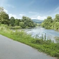
Over 64 kilometers from Windeck to the mouth into the Rhein, it leads partly on newly designed paths right through the nature region Sieg. Also a joy for families, except for two short climbs, the route is always flat and away from road traffic through a varied river landscape. Whether sporty ambitious as a one-day route or cozy and enjoyable in two stages – the Sieg cycle route meets all demands. Along the way, cafés and beer gardens invite you to linger: how about a stop at the Sieg waterfall in Windeck-Schladern or a swim in the Sieg floodplains near Mondorf?
TRAIL & RAIL: Whether you as experienced cyclists tackle the 64 km long Sieg cycle route as a day route or just want to connect a few destinations – with S-Bahn line 12 and regional train line RE9 you can easily reach all stage locations and return to the starting point by train.
Good to know
Best to visit
Directions
The cycle route is marked in both directions and easy to ride. At the Rhein, there is the possibility to extend the route on the Rhein cycle route. Not everywhere are there places to stop for food and drink - bring provisions!
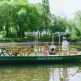
Only a few kilometers north of the Bonn city border, the Sieg cycle route starts in Niederkassel-Mondorf. The starting point is on the Rhein riverbank shortly before the ferry pier. The maritime atmosphere invites you to watch the hustle and bustle of ships on the Rhein and admire the elegant motor yachts in the harbor basin. On the left of the ferry extends a peninsula whose tip is bounded by a beacon – here the Sieg flows into the Rhein. Along the harbor basin and the edge of the town, the Sieg cycle route soon passes two arms of the Sieg. On an asphalted little road, it goes in the direction of the Sieg ferry. Shortly before the ferry, there is the choice to cycle through the floodplain to Troisdorf on the right or left side of the Sieg; both variants are equivalent. Although not long in the saddle yet, a rest in the beer garden of the guesthouse “Zur Siegfähre” only enhances the cycling experience, so the short detour is highly recommended. Here crossing the Sieg by ferry is also possible. Constantly following the dike crowns on both river sides, the views wander over wonderfully wide floodplains. Along lush meadows, the Sieglarer See is passed, which is a popular breeding ground for water birds. At the outskirts of Troisdorf, both ways meet at the Sieg bridge, and soon the view falls on the Michaelsberg Abbey rising above the town of Siegburg. Here a detour into the old town is worthwhile with many places to eat and shop around the market. Riding to the only a few kilometers away Hennef, the cycle route repeatedly leads close to the riverbank. The Hennef station is passed immediately nearby, and after circling the settlement Weldergoven, the cycle route runs close to the railway tracks. At the height of Lauthausen, the Sieg shows itself from its powerful side: with a roar, the water rushes down a rapid and offers a lively sight. About 200 m opposite the Blankenberg stop, the Sieg is crossed in the direction of Oberauel, and soon the mighty ruins of Blankenberg Castle greet from about a 150 m high mountain ridge. The castle ruins and the village of the same name with its beautiful half-timbered houses and well-preserved town wall form a fascinating historic ensemble and definitely deserve a visit. If you want to enjoy the Sieg cycle route as a two-day route, the town of Blankenberg is a suitable stage destination as it is “halfway”. The cycle route winds along the Sieg loops and is immediately bordered by beautiful deciduous forest and the river after the small village Auel. Behind Auel, the railway crossing awaits with a special feature. To open the locked barrier, you press a call button and speak briefly with an employee in the signal box. In the same way, you notify afterwards that you have passed the crossing. The cycle route continues over two new bicycle bridges directly to the station and then to the noteworthy Merten castle. Behind the village exit, a steep ascent into the forest must first be overcome. Before it goes through the settlement Lützgenauel again directly down to the Sieg riverbank, the view at the highest point of Eitorf can make up for the effort. The ascent can be bypassed. Between Merten and Bourauel, the cycle route can be used next to the state road 333 for this. Afterwards, on the opposite riverbank lies Eitorf, whose station can be quickly reached via a bridge to Siegpark. The further route up to Dreisel is exactly as you imagine an ideal river cycle route. Without interruption, you roll leisurely directly along the riverbank. Nothing disturbs the view over the lush green meadows stretching along the river loops. On the opposite Sieg side, dense mixed forests climb the steep mountain slopes and it almost seems as if they form the natural frame for the river scenery. Past Herchen station, it is about 1.5 km to the village. Here and a little later at the Sieg loop near Röcklingen, the river is crossed twice each time. After passing the S-Bahn stop on the edge of Wilberhofen, the asphalted path runs to Dreisel. From Dreisel, a steep climb with about 70 meters height leads up to Maueler Berg. For the return trip by train, there are two possibilities: either from the S-Bahn stop Dattenfeld in the district Wilberhofen or from the station in Schladern, about 3 km away. After the rapid descent, a detour to the Sieg waterfall and the impressive castle ruins in Windeck Schladern is worthwhile. Up to Rosbach, the current end of the Sieg cycle route, the route leads between river and road. In Rosbach, there is the possibility to return to the starting point by train. Those who wish to continue in the direction of the Sieg source are advised to use the German Bahn (RE 9) between Rosbach (Sieg) and Mudersbach-Niederschelderhütte.
From Mudersbach/Niederschelderhütte to the Sieg source we recommend this route.
Tour information
Familiy-Friendly
Stop at an Inn
Directions & Parking facilities
Niederkassel-Mondorf to Windeck-Rosbach station
Current departure times Troisdorf station
Current departure times Windeck-Rosbach station
The starting point Niederkassel-Mondorf is accessible on the right bank of the Rhein via Bonn-Villich stop with line 66 and on the left bank of the Rhein via the Bornheim-Roisdorf DB station (plus Mondorf ferry). You can arrive by bike via the Rhein cycle route.
Optimally connected: By train you can easily reach any starting point and return to the starting point by train.
Bonn-Vilich stop: line 66 towards Siegburg
Troisdorf station, Siegburg station, Hennef station, S-Bahn stop Im Siegbogen, S-Bahn stop Blankenberg, Merten station, Eitorf station, Herchen station, Dattenfeld /Wilberhofen, Schladern, Rosbach station.
Author
Naturregion Sieg
Organization
Rhein-Sieg Tourismus
License (master data)

Author´s Tip / Recommendation of the author
Along the cycle route there are some bike rental stations, mainly at bus and train stops.
The rental can start at any station and end at any station and is done via app (www.nextbike.de/de/rsvg).
Safety guidelines
From a water level of 2.30 m at Pegel Menden parts of the cycle route may be flooded.
Nearby
