


- 2:40 h
- 35.40 km
- 313 m
- 310 m
- 72 m
- 263 m
- 191 m
- Start: S-Bahn stop "Im Siegbogen," Bodenstrasse, 53773 Hennef (Sieg)
- Destination: S-Bahn stop "Im Siegbogen," Bodenstrasse, 53773 Hennef (Sieg)
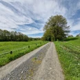
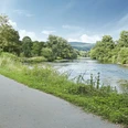
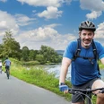
Idyllic stream valleys: The route runs quietly and free of cars at the beginning in the Hanfbach valley along a former railway track. Varied landscape and traces of former mills please the eye. Thanks to the slight gradient in the Krabach valley, the route can be comfortably finished on the Sieg cycle path. There, idyllic meadow areas and the picturesque half-timbered village Auel bring feelings of happiness.
Good to know
Best to visit
Directions
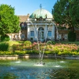
The route begins at the stop "Hennef im Siegbogen." The S-Bahn lines S12 and S19 run there between Cologne and Windeck. Numerous free parking spaces are also available. At the start, the route is not signposted. A GPX track is available for orientation. After a short ride through a small residential area and the underpass of federal highway 8, open countryside is reached directly. Behind the village of Petershohn, the path leads to a small hill from which the lower Sieg valley with the town of Hennef can be overlooked. The short descent then leads into the Hanfbach valley. From here to Krautscheid, signage provides additional orientation. In the Hanfbach valley, a narrow-gauge railway once ran to Asbach for both passenger and freight traffic. The cycling route runs with a slight incline on or next to the former railway embankment, alternating constantly between forest and meadows. At the villages of Dahlhausen and Hanf, the side of the stream is changed each time. Shortly before Krautscheid, the NRW/Rhineland-Palatinate state border is reached. In Mendt, a memorial stone points to the old railway line in the Hanfbach valley. From here, it is only a short distance to the highest point of the route. Once federal highway 8 has been crossed, the route descends into the idyllic Krabach valley. While the Hanfbach valley was characterized by an open and varied landscape, the approximately 10 km long section of the Krabach valley is dominated by nature. Therefore, it is under special protection. In the small village of Bach, the Krabach flows into the Sieg. The Merten castle can already be seen on the opposite side of the river. The entire complex can be visited. There is a place to stop in the Orangerie. From Merten castle, the last approximately 7 km lead back to the starting point via the very well-developed and signposted Sieg valley cycle path.
Tour information
Loop Road
Stop at an Inn
Equipment
- GPS navigation required
- Trekking or mountain bike recommended
Directions & Parking facilities
S-Bahn stop "Im Siegbogen," Hennef: Lines S12 and S19
Alternatively, you can also start the cycling route at the S-Bahn stop Merten (Sieg), Eitorf-Merten, or at the S-Bahn stop Blankenberg (Sieg), Hennef-Stein.
Additional information
For more information, contact the
Visitor Center Sieg Nature Region, phone +49 2292 / 956 20 23, info@naturregion-sieg.de
or the
Tourist Information Hennef, Frankfurter Str. 97, 53773 Hennef (Sieg), phone +49 2242 / 19433, tourismus@hennef.de
Literature
Our brochure "Sieg cycle path and route recommendations in the Sieg nature region"
is available here:
Tourist Information Hennef, Frankfurter Str. 97, 53773 Hennef (Sieg), phone +49 2242 / 19433, tourismus@hennef.de
Author
Naturregion Sieg
Organization
Rhein-Sieg Tourismus
License (master data)

Author´s Tip / Recommendation of the author
Tip: Visit the beautiful Merten castle and stop at the Orangerie.
Safety guidelines
The route is not signposted.
Map
Nearby