Small nature circular route - Route 6 Beerheide

8.97 km long
Round trip
Difficulty: medium
Condition: medium
Great panorama
Hiking
  • 2:25 h
  • 8.97 km
  • 147 m
  • 147 m
  • 627 m
  • 738 m
  • 111 m
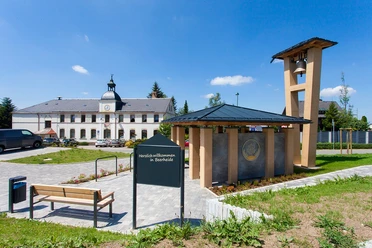
  • Start: Cultural Center Beerheide
  • Destination: Cultural Center Beerheide
Nice hike from the Cultural Center Beerheide over NSG Grünheider Hochmoor, Vogtlandsee, Röthelstein back to Beerheide

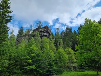
Starting from the Cultural Center Beerheide, cross Klingenthaler Street, follow Frankenweg to the junction with K 7826, then turn right towards Grünheide until Rautenkranzer Street. Before Grünheide forest park, turn right into Torfweg and hike west along NSG Grünheider Hochmoor. Then reach the turn right towards Vogtlandsee. From here, walk on the Floßbahn and cross Klingenthaler Street, then hike to the Großer Riß via Rißweg I to the bridge over the Rote Göltzsch. Cross this bridge and walk left to Röthelstein. Via the staircase you reach the observation platform and enjoy the great view! The hike continues along Röthelsteinweg to the locality Beerheide, via Straße des Friedens, Birkenweg, Obere Straße to Rempesgrüner Straße and back to the starting point at the Cultural Center Beerheide.

Waypoints

Start
Start
Cultural Center Beerheide
© Archiv TVV/S. Theilig | CC-BY-SA
Destination
Destination
Cultural Center Beerheide

Good to know

Best to visit

suitable
Depends on weather

Directions

Cultural center – Coffee house path to the coffee house – Crossing Klingenthaler Street – Frankenweg until the junction with K 7826 – Turn right towards Grünheide until Rautenkranzer Street – before Grünheide forest park turn right into Torfweg – west along NSG Hochmoor – turn right towards Vogtlandsee – west of Vogtlandsee turn onto Floßbahn – along Floßbahn crossing Klingenthaler Street to Großer Riß – over Rißweg I to the bridge over the Rote Göltzsch – crossing the bridge – after the bridge turn left to Röthelstein – via staircase to the observation platform – along Röthelsteinweg to the locality Beerheide – uphill via Straße des Friedens – turn left into Birkenweg – straight ahead along Obere Straße to Rempesgrüner Straße – Cultural center

Tour information

  • Loop Road

  • Tour with Dog

Equipment

Sturdy footwear

Directions & Parking facilities

Beerheide is located in the southwest of the Free State of Saxony. The nearest larger cities in the area are Plauen, Zwickau and Reichenbach. You can reach Beerheide comfortably via the A72 motorway. Motorway exit: A72 Treuen exit towards Treuen and continue on B169 towards Auerbach, then take S300 towards Klingenthal, or motorway exit: A72 Plauen East exit onto B173 towards Falkenstein, then to B169 to Auerbach, and then on S300 towards Klingenthal
At the hiking parking lot at the forest sports ground in Beerheide, 90 parking spaces are available, or you can park in one of the public parking lots in the village of Beerheide
Information about arrivals by bus and train can be obtained from the Vogtland Tourism and Transport Center at www.vogtlandauskunft.de or by calling the hotline 03744 19449.

Additional information

www.erholung-vogtland.de/Aktiv/Wandern

www.beerheide-vogtland.de

Literature

Brochure "Hiking routes around Beerheide" available at the Vogelsgrün Guest House or the Auerbach Tourist Information

Author

Claudia Gerisch

Organization

Vogtland - Sinfonie der Natur

License (master data)

Claudia Gerisch
License: Attribution, ShareAlike

Author´s Tip / Recommendation of the author

Rest at Vogtlandsee
Grünheider Hochmoor
Ascent to the Röthelstein
Playground at the Cultural Center Beerheide

Nearby