- 2:00 h
- 6.53 km
- 182 m
- 182 m
- 150 m
- 272 m
- 122 m
- Start: Parking lot at the former forest and forestry museum, Kurstraße 7, 32689 Kalletal
- Destination: Parking lot at the former forest and forestry museum, Kurstraße 7, 32689 Kalletal
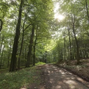
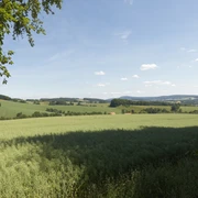
The A1 walking trail offers a varied landscape over approx. 6.5 km around Heidelbeck: starting in Kurstraße, it heads south towards Asendorf with a view of wide rhubarb fields. The route continues through the forest in the direction of Osterberg/Lange Wand. A detour up to the "Familienplatz" is worthwhile, as the ascent is rewarded with a fantastic view and a seating area for a rest.
Good to know
Pavements
Street
Asphalt
Gravel
Trail
Path
Best to visit
suitable
Depends on weather
Directions
Starting from the parking lot, the trail leads down an asphalt path to the Osterberg farmstead and on to the Lange Wand. The trail continues along a field path to the "Hohlenweg" road. Turn left onto Bauerbergweg and continue along Schulstraße. Parallel to Heidelbecker Straße, the tour leads to the sports field. Below the sports field, a path on the right leads down into the village. Once you reach Kurstraße, you reach the former forest and woodland museum. Turn right into the street "Am Rachensbornbach", then right again onto a farm track in the direction of Asendorf. At the next junction, the circular route leads left up into the forest. At the next crossroads in the forest, take the left-hand path again and follow it straight on through the forest back to the Osterberg parking lot.
Tour information
Labelling
Loop Road
Possibility of Accommodation
Stop at an Inn
Equipment
sturdy shoes
Directions & Parking facilities
Parking lot at the former forest and forestry museum, Kurstraße 7, 32689 Kalletal
Always know what's running: The smart number for buses and trains in NRW 01803 504030 (timetable information for €0.09/min. from a German landline, mobile max. €0.42/min.)
Author
Gemeinde Kalletal
Organization
Gemeinde Kalletal
License (master data)
Gemeinde Kalletal

Author´s Tip / Recommendation of the author
Refreshments available at the Schlosskrug, Heidelbeck
Map
Hiking and cycling map Kalletal
Hiking map NRW "Nordlippisches Bergland"
Nearby