Through the Rothenthal Alps


- 1:19 h
- 3.70 km
- 121 m
- 121 m
- 259 m
- 333 m
- 74 m
- Start: Mouth of the Göltzsch
- Destination: Mouth of the Göltzsch
The impressive rock formations that rise along the Weiße Elster south of Greiz are called the Rothenthal Alps.
Good to know
Pavements
Best to visit
Directions
Facing the mouth of the Göltzsch into the Weiße Elster, turn right. Follow the yellow dot marking and cross the street bridges over the Elster and the Elstertalbahn railway line, then carefully cross the B 92 straight ahead. A narrow path leads uphill through a garden area into the forest.
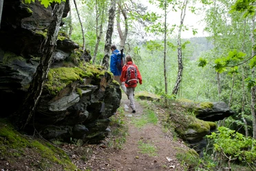
On narrow paths with many switchbacks and past several viewpoints on rocky ledges, you reach the Greiz district of Rothenthal at Mühlberg.
It is worth pausing repeatedly along the entire circular route to take in the views around. You stay at elevation, pass a memorial, and reach the forest area of Eichleite. Soon you must descend steeply to the left toward the Elster.
Under the old railway track and past an old river weir, you come back to the B 92, where you cross the road at the Elster bridge. Just after crossing the Elster, turn left again and continue hiking through the forest. The hiking path now leads along the right side above the Weiße Elster on the slope of the Rothenthal slope. At the Bastei rock, you have a fantastic view of Rothenthal. Then continue through the forest back to the starting point of this short hiking route.
Tour information
Loop Road
Directions & Parking facilities
You can reach Greiz with the Vogtlandbahn on the Gera-Plauen/Weischlitz route: www.vogtlandbahn.de
For bus travel information, please refer to www.bus-greiz.de
Literature
Author
Tourismus Marketing Gesellschaft Sachsen mbH
Organization
Vogtland - Sinfonie der Natur
License (master data)
Vogtland - Sinfonie der Natur

Author´s Tip / Recommendation of the author
Safety guidelines
Nearby


Download GPX file