


- 3:40 h
- 11.77 km
- 290 m
- 276 m
- 103 m
- 304 m
- 201 m
- Start: Town center of Steinhagen
- Destination: Town center of Werther

Good to know
Pavements
Best to visit
Directions
Steinhagen town center - B68 - Kammweg Palsterkamp - Kaiser Friedrich Hütte - Arminiusquelle: The resting place "Riechen" - bone mill - Werther center - Protestant church - Storck house - Böckstiegel house
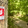
The hiking trail is well signposted in both directions. Please follow the red and white signs with the inscription 'Weg für Genießer' and the 'G'.
Tour information
Stop at an Inn
Equipment
Directions & Parking facilities
Always know what's running: The smart number for buses and trains in NRW 0800 6 50 40 30.
Additional information
http://www.geniesserweg.de
Municipality of Steinhagen, tel. 05204 9970, http://www.gemeinde-steinhagen.de
Town of Werther (Westphalia), tel. 05203 7050, http://www.stadt-werther.de
Author
Arbeitsgemeinschaft Weg für Genießer, c/o pro Wirtschaft GT GmbH
Organization
pro Wirtschaft GT GmbH
License (master data)
Arbeitsgemeinschaft Weg für Genießer, c/o pro Wirtschaft GT GmbH

Author´s Tip / Recommendation of the author
Safety guidelines
Map
Nearby

