- 4:30 h
- 48.37 km
- 650 m
- 650 m
- 87 m
- 345 m
- 258 m
- Start: Parking lot on the Weser (K31), 37688 Beverungen-Wehrden
- Destination: Parking lot on the Weser (K31), 37688 Beverungen-Wehrden
From Wehrden, the route leads past two old gravel lakes in the direction of Blankenau. The very narrow Weser valley here is spanned by an old railroad bridge that is still in use and is part of the Ottbergen - Nordhausen line. Behind the bridge, the Weser valley widens out on the left-hand side, and on the right-hand side the forest extends as far as the Weser cycle path. After around 500 m, a mighty quarrystone wall begins, which used to carry an old railroad line towards the Sauerland. However, the railroad line has been abandoned. You can take a short detour through an arched bridge to the village of Blankenau. We continue along the Weser cycle path towards Beverungen. On the other side of the Weser you can see the village of Meinbrexen. The church in Meinbrexen is home to one of the largest bat colonies under its roof. The greater mouse-eared bat apparently feels particularly at home here. The parish harvests around 1,000 liters of guano every spring and sells it.
After another 4 km, we see the Beverungen granary. Grain is still transported from here by cargo ship on the Weser. Turn right in front of the granary. For the next 1.8 km, we cycle through residential areas with a 30 km zone. We leave Beverungen via the Zum Wandelsberg road. And as the name suggests, it is now uphill. This is followed by the old Drenker Straße, which is now only open to agricultural and forestry traffic. It runs through the beautiful Springbach valley. After a short, steeper section, the ascent is leisurely. After around 5 km, we reach the Elisenhöhe. There is a trade union-run seminar house here. From here, it is worth taking a look back over the Weser valley. To our right is the village of Drenke, which we turn towards next in a small arc. We ride around the Elisenhöhe and reach Drenke. We head north uphill again. If visibility is good, it is worth making a short detour to the Drenke memorial, which commemorates the fallen of the wars. From the Eggeberg there is a wide view of the Weser valley. The white façade of Fürstenberg Castle can be seen on the right. Straight ahead is Höxter, and behind it you can see Holzminden, 20 km away.
After the ascent, the route continues uphill for a short distance before descending into the Nethe valley. However, you should take the gradient of up to 20% slowly so as not to miss the view of the Nethe valley. It is also worth making a short stop at the Bruchhaus memorial. There is also a beautiful view of the Nethe valley from here, with Bruchhausen in the foreground and Ottbergen to the right behind. The village of Bruchhausen is still home to many half-timbered houses that are well worth seeing, and we recommend taking a short tour of the old town center before continuing over the Nethe Bridge to Ottbergen. From Bruchhausen, we take the Netheradweg to Ottbergen. In Ottbergen, we pass the school and the church.
Before the next ascent, it is worth taking a look at the beautiful Nethebrücke bridge in Ottbergen. A few benches here invite you to take a break by the river. Behind the church, simply turn right as far as the Nethebrücke bridge. Around the church is the old town center of Ottbergen with some very beautiful half-timbered houses. The tour continues to the left behind the church. Continue along Nethestraße until you reach the B 64, cross the B 64 and follow Bahnhofstraße. After the underpass, we turn left and cycle through the small industrial estate to the next exit on the right. Now it's time to downshift. The next 1.4 km are quite a challenge. It's worth getting off the bike here so as not to miss the view to the rear. Below us on the left is Ottbergen and further to the right Bruchhausen. Opposite, we can see the Drenker Höhe, over which we have come. At the top, with good visibility, we can see Haarbrück, the highest village in the Höxter district. Halfway up the ascent, the path forks. We keep to the right and follow the path to the edge of the forest. There is a bench on the left and it is worth taking another look back. On the left, we can see over the heights far into the Weser valley.
Another short, steep climb and we follow a well-maintained gravel forest path to the left, which runs straight ahead to the road. At the end of the forest path, we come to a barrier, which is sometimes closed. However, we can bypass this on the right. At the road, keep right and follow the road for 300 m.We have left the forest behind us and are now on the Bosseborner Höhe. Turn right along a short stretch of gravel agricultural road. After 100 m, the path continues to the left and is asphalted again.
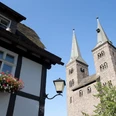
Here, the landscape once again lives up to the name Kulturland Kreis Höxter. The route leads through meadows and fields to Bosseborn, and the view of the wooded valley cuts to the Weser valley opens up again and again. It gives the impression of being on a mountain pasture. We only touch the village of Bosseborn briefly. 50 m after leaving the village, we turn left off the district holiday road behind the sports field and head towards Heiligenbergkapelle, which is located on the hill in the direction of Ovenhausen. Here, too, there are beautiful views of the wooded valley incisions and beyond into the Weser valley and as far as the Eggegebirge mountains. The Corvey World Heritage Site is clearly visible with the two towers of the Westwerk. Here we also take a section of the Pilgrims' Way, which continues from Corvey via Ovenhausen towards the Ruhr region. From Heiligenberg, a steep descent takes us to Ovenhausen, where we join the R 1 cycle path at the bottom of the village. We cycle through the Grube valley past some fish ponds in the direction of Höxter. The next village is Lütmarsen, which we cycle around on the right-hand side before reaching the town of Höxter. The path meanders along the Bollerbach stream, sometimes on the left and sometimes on the right. Passing the beautiful half-timbered houses and the old town hall of Höxter, we reach the Weser bridge. Behind the railroad, but before the Weser bridge, we turn right over a ramp onto the Weser cycle path. Caution and consideration are required on the descent, as the Weser promenade is also used by many pedestrians. We follow the Weser cycle path in the direction of Beverungen.
We pass the Godelheimer Seen leisure facility. The Ziegenberg with a few cliffs rises up on the right behind the leisure facility. Next up is the Brunsberg, on top of which the Brunsburg castle once stood. Some remains still exist. At the top of the slope is the Brunsberghütte, which is a popular jumping-off point for hang-gliders and paragliders.Further on, we pass another recreational lake before reaching the Nethemündung nature reserve. Information boards provide an insight into the flora and fauna.We continue over the Nethe bridge towards Beverungen. The view falls on an old railroad bridge. The Kathagenberg now rises up on the other side of the Weser and Fürstenberg Castle lies on the red sandstone rocks directly on the slope. Passing a gravel lake, we come to the walls of an old tithe barn made of quarry stone, whose sandstone roof unfortunately collapsed a few years ago. There is a bench on the left. From here, we can take another look at the mountains over whose heights we have ridden.
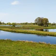
A short descent and we have a beautiful view of the Weser valley opening up, in which Wehrden lies. Passing the small public castle park and a few allotments, we reach the start and finish point of our tour, the Weser parking lot in Wehrden.Good to know
Pavements
Best to visit
Directions
The next turn-off to the left leads to the Drenk memorial. We also have to take this road back and turn left again. We follow the path straight ahead and then take the descent to Bruchhausen. Beware, there is a 20% gradient here in places.
We reach the cemetery and turn left onto Hüweweg, which then continues to the right. At the next junction, we turn left into Linnenstraße, then right into Im Ring and then left again until we reach the paved Brokhusenstraße, which we follow to the right. The road leads out of Bruchhausen over the Nethebrücke bridge and we turn right into Steinäckerstraße. We follow the Netheradweg signs to the right and walk past the Ottberg school to the church.Behind the church, we turn left into Nethestraße. We cross the B 64 and follow Bahnhofstraße. After the underpass, we turn left into Am Lintrott and continue to the next junction on the right. Continue straight on up the hill and follow the asphalt road. There is a Y-junction where we keep right until we reach the edge of the forest. We follow the gravel forest path to the left until we reach the road. We turn right and follow the road for 300 m. A short 200 m gravel path to the right takes us onto an asphalt farm track, which we follow to the left. The path leads back to the road and then right again into the fields. At the end, turn left again towards Bosseborn. At Heinemannstraße, we turn right and 50 m further on turn left into Am Kreuzkamp. We follow the road, which ends in a traffic circle, and take the first exit on the right. After 100 m, we turn left onto the farm track after the sports field. We initially go straight ahead and come to a Y-junction. Here we follow the signs for "Heiligenbergkapelle" on the left until the path continues to the right at the end. Continue straight on into the forest to the Heiligenberg chapel. Our descent branches off to the left before the forest at an oak tree. Take care on the descent. A car can sometimes come along the single-track road. We ride down Heiligenbergstraße and continue straight on via Bornstraße to Jätzerstraße. From here, we follow the signposted R 1 cycle path to Höxter until we reach the R 99 Weser cycle path at the Weser bridge, which we follow in the direction of Beverungen to our starting point in Wehrden.Tour information
Loop Road
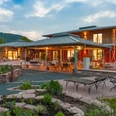
Stop at an Inn
Equipment
Directions & Parking facilities
Navigation address for the Weser parking lot Wehrden:
37688 Beverungen, Weredunstraße (smallest no.)
Navigation address:
37688 Beverungen, Weredunstraße (smallest no.)
Timetable information at: www.nordwestbahn.de (Region Ostwestfalen).
Additional information
Information about the Nethe estuary nature reserve can be found here:
http://www.kulturland.org/Erlesene-Natur/Erlebnisgebiete/Nethemuendung/
A general description of the landscape with information on geology, soil types and wildlife can be found here in the description of the Weser Heights Trail hike
Author
Markus Niemann
Organization
Tourist-Information Beverungen
License (master data)
Markus Niemann

Author´s Tip / Recommendation of the author
Safety guidelines
A helmet and high-visibility clothing are always advisable for cyclists.
You cycle the route described at your own risk.Nearby