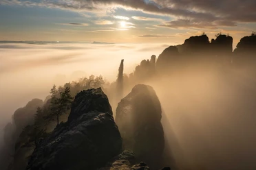
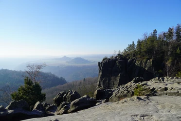
Via the Wildschützensteig to the Schrammstein viewpoint
- Photos & Map
How would you like to arrive?
- Description
- Good to know
- Nearby
Download GPX file
- 3:30 h
- 9.07 km
- 313 m
- 313 m
- 174 m
- 386 m
- 212 m
- Start: Spa gardens, Ostrava
- Destination: Spa gardens, Ostrava
Ostrau - Emmabank - Klüftel - Lattengrund - Schrammtor - Wildschützensteig - Schrammsteinaussicht - Mittelwinkel - Schießgrund - Zschiehädelweg - Ostrau
Good to know
Pavements
Best to visit
Directions
From here, we stay on "TK 7", one of Bad Schandau's terrain cure trails, which we walk in the opposite direction. We continue along the edge of the forest and past garden plots on the narrow path, leave Meergründel on the right and turn right at the next large signpost in the direction of Lattengrund - Schrammsteine (marked "Blauer Strich"). Steps lead us through a small gorge, the Klüftel, which gives us a foretaste of the rest of the tour: Sandstone rocks overgrown with moss and ferns line the path.
We follow the "blue line" down into the Zahnsgrund, cross the road and enter the Lattengrund on the other side. The Lattengrund is a narrow valley, bordered by rock faces and lush greenery. At the top, at a fork in the road, we keep left and walk to the large national park information board. From here, we follow the markings to the Großer Schrammtor gate, which we pass through on a sandy path (here we are also on the Malerweg trail). The Großer Schrammtor is one of the mighty cuttings in the Schrammsteine. The hiking trail leads narrowly between eroded sandstone rock faces.
After a short while, we come to the Wildschützensteig trail, which turns off to the left. The Wildschützensteig is a staircase secured with metal steps, ladders, wooden planks and handrails through a cool, damp gorge, which takes us almost to the top to the Schrammstein viewpoint. After the ascent, we keep left and hike up more steps to the Schrammstein viewpoint. It is exposed on the rugged Schrammsteine and offers a magnificent all-round view of the rocky landscape.
Back from the viewpoint, we leave the Wildschützensteig trail on the right and hike to the next path branching off to the left, the Mittelwinkel (marked "green dot"). We descend here via steep steps and ladders. At the next large crossroads at the bottom, we turn left towards Schrammtor. On the wide path, we catch another glimpse of the Schrammstein range from below. At the next crossroads, we turn right and shortly afterwards left, now always following the "green dot", which shows us the way through the Schießgrund to Ostrau.
As we descend through the Schießgrund, it is worth taking a look up at the rocks, where iron bands are clearly visible in the sandstone. At the bottom, we cross the road again; if you want to stop off at the Schrammsteinbaude or take a shortcut and get on the bus there, turn left here. We return to Ostrau via the "Zschiehädelweg", which leads straight ahead directly opposite the Schießgrund and soon climbs over steps, some of which are secured with a chain. At the top, we come to Falkensteinstraße, on the other side of the road is a footpath, which we follow to the left until we turn left again at the first crossroads in the village and can already see the bus stop at the spa gardens.
Tour information
Loop Road
Stop at an Inn
Summit
Directions & Parking facilities
You can shorten the tour by skipping the loop via Ostrau and getting off and on at the Schrammsteinbaude.
Additional information
Author
Maren Pussak/Nationalparkverwaltung Sächsische Schweiz
Organization
Tourismusverband Sächsische Schweiz
License (master data)
Author´s Tip / Recommendation of the author
Safety guidelines
It is not permitted to leave the paths in the Saxon Switzerland National Park. The Wildschützensteig can only be walked on the ascent. If you want to reverse the direction of the tour, take the Jägersteig for the descent.
Please take particular care in winter, as there is a risk of falling in some places on the Schrammsteine in icy conditions. We only recommend this tour in icy weather.
Nearby


