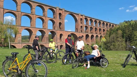
Accessible hiking route from Mylau to the Göltzschtal Bridge


- 0:28 h
- 1.61 km
- 45 m
- 3 m
- 299 m
- 344 m
- 45 m
- Start: Market Mylau
- Destination: Market Mylau
The distance, including the return trip, is 3.5 km long and has hardly any elevation differences. The obstacles are mainly due to the non-lowered curbs and many potholes.
Waypoints

Good to know
Best to visit
- suitableDepends on weather
Directions
We begin our hike at the market in Mylau. It is accessible by bus line V-73 Plauen – Reichenbach. Those using a wheelchair on this line must register in advance. There are parking spaces at the market for cars, including disabled parking spaces. However, it is advisable to drive directly to the Göltzschtal Bridge by car.
We leave the market heading towards B173 and follow it for 600 m towards Netzschkau until we reach the metal construction company on the right side of the street. Here we turn right onto Karl-Marx-Ring. Until then, the surface was paved with slabs or asphalted. From the turn, the surface is poor with many potholes. After 1.3 km, we reach the area around the Göltzschtal Bridge. It is 78 m high, has four levels with 98 vaults.
Tour information
Cultural Interesting
Suitable for Pushchair
Additional information
Vogtländischer Knollenring e.V.
Schönecker Str. 35
08606 Mühlental OT Tirschendorf
info@vogtlaendischer-knollenring.deLiterature
Further information can be found on the pages of the Vogtland Tourism Association at www.vogtland-tourismus.de or by calling 03744 188860, as well as in other tourist information offices along the route.
Author
Tourismus Marketing Gesellschaft Sachsen mbH
Bautzner Straße 45/4701099 DresdenOrganization
Vogtland - Sinfonie der Natur
License (master data)
Vogtland - Sinfonie der Natur