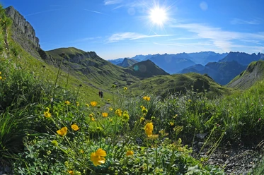
Alpenkranz 1st stage: Klewenalp - Hinterjochli - Gitschenen (Isenthal)


- 3:00 h
- 7.53 km
- 597 m
- 632 m
- 1,523 m
- 2,106 m
- 583 m
- Start: Mountain station of the Beckenried Klewenalp cable car
- Destination: Gitschenen in Isenthal
From Klewenalp NW (1593 m), which is conveniently reached by a spacious cable car from the village of Beckenried, we follow the broad mountain path to the "Alpstubli." Then the path descends to the restaurant Tannibuel (1525 m). From there, a red-white marked ascent leads us up to the Mälchgädeli (1620 m) toward Alp Stafel and further to Höch Stand (1789 m). After the Chaelenegg (1938 m), the route now climbs steeper through the Chälen to the saddle of Hinterjochli (2105 m). We hike in a wide arc downhill from Hinterjochli and find an ideal resting place "bi den Seelenen."
Then follows the descent over the Isenthaler Alp Oberbolgen (1820 m), grazed by cattle in summer, and steep switchbacks down to the Alp Unterbolgen (1657 m). Along the rock ribs of "Unter Zingel" to a mountain path, we continue through colorful alpine meadows to the mountain homestead Kneiwies (Chneuwis 1565 m). Those who want to go directly down to Isenthal hike a few more minutes to the mountain station of the LSB Isenthal - Gitschenen (1538 m). At the mountain guesthouse at the station, Berggasthaus Gitschenen, holiday guests as well as hikers and tourists are always welcome.
- Technical difficulty: T2 white-red-white
Good to know
Pavements
- Unknown (1%)Trail (35%)Path (64%)
Best to visit
- suitableDepends on weather
Tour information
Mountain Railway Tour
Nature Highlight
Author
Sanna Laurén
Organization
Verein Urner Wanderwege
License (master data)
Sanna Laurén