Arnsgrüner Kirchsteig
 bei Adorf")


- 0:56 h
- 3.34 km
- 78 m
- 128 m
- 498 m
- 574 m
- 76 m
- Start: Arnsgrün
- Destination: Kurpark Bad Elster
It connects the Adorf district of Arnsgrün with Bad Elster.
Waypoints

Good to know
Pavements
Best to visit
Directions
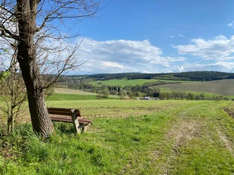
Most hikers start at Adorf train station or at the parking lot in front of "Klein-Vogtland" and the forest pool. The starting point of the hike is finally Arnsgrün.
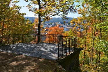
We leave this district of Adorf heading south, turn left from Bergstraße into Kirchsteig. After the meadow, we keep to the right to continue southwards. Then, after approximately 2 km, we cross the Zeidelweidebach. After another approx. 2 km, we reach the outskirts of Bad Elster. There, you can either turn back at the trout pond and take the same path back, or walk a few meters over the bridge on Beuthstraße to enter the Kurpark on the left. Here, 2-3 park paths wind forward to the Kurhaus. Crossing the street, behind the bathing and sauna area and the saline spa, there is the option to walk to the Bad Elster train station.
Tour information
Stop at an Inn
Directions & Parking facilities
Take the Vogtlandbahn to Adorf or Bad Elster: www.vogtlandbahn.de
Information on travel by bus and train is available from the Vogtland Tourism and Transport Center at www.vogtlandauskunft.de and by phone at 03744 19449 as well as at the tourist information centers in Adorf and Bad Elster.
Additional information
Author
Tourismus Marketing Gesellschaft Sachsen mbH
Organization
Vogtland - Sinfonie der Natur
License (master data)
Vogtland - Sinfonie der Natur

Author´s Tip / Recommendation of the author
Nearby

