Around Freital (marked with "Green Line")


- 11:01 h
- 38.13 km
- 884 m
- 884 m
- 151 m
- 368 m
- 217 m
- Start: Parking lot at Carl-Thieme-Straße in Freital-Potschappel. Of course, the route can also be started at any other point and walked in both directions.
- Destination: same as the starting point
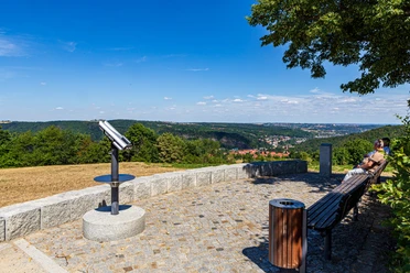
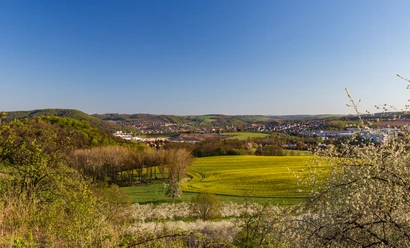
Freital is located in the Döhlen Basin between the romantic Rabenauer Grund and the Plauenscher Grund, which belongs to Dresden. The circular hike leads over the green slopes around the city, from which fantastic new views open again and again. A highlight is the viewing platform at the König-Albert-Denkmal on Windberg, the distinctive local mountain of Freital. The very varied path leads through meadows and forests as well as the former villages now belonging to the city: Pesterwitz, Wurgwitz, Niederhermsdorf, Saalhausen, Weißig, and Kleinnaundorf.
Waypoints


Good to know
Pavements
Best to visit
Directions
We start in the direction of Oberpesterwitzer Straße, turn right twice and go uphill on Am Jochöh. Behind the last house, we leave the road to the left and continue through the forest to the Jochhöhschlösschen. From there, it goes to the town center of Pesterwitz. At the village square, we continue between the guesthouse and the historic manor towards Jakobuskirche, which we leave on the right. At the pottery, we continue straight downhill to the 8th adit of the Deep Elbe Tunnel. We follow the path downhill to the Almabach and turn right at the foot of the Burgwartsberg. Back on the road, we follow it to the first houses, where we turn right and follow the Hammerbach to the former Kohlsdorfer guesthouse, where we cross Pesterwitzer Straße and at the end of the vineyard turn left again into the valley and reach Wurgwitz on the other side.
Along the northern outskirts, it goes downhill again into the Wiederitz valley. At Gartenstraße, we turn left towards Niederhermsdorfer Hof. Then right to Zur Quäne, uphill before the school, and after the curve, left onto the hiking trail, which we follow to Saalhausen. From there, it goes through Weißiger Forest to Weißig and along the outskirts to the bus turning area and further to the triangulation pillar on Opitzer Höhe. At the crossroads, we turn left and walk along the forest edge, then via Förster-Claus-Weg towards Hainsberg, cross Hirschbergstraße in the valley, and go over the Taubenleite and the Backofenfelsen to Breiten Grund, which we follow downhill to Tharandter Straße.
Further on over Somsdorfer Straße and Hainsberger Straße. After crossing the narrow-gauge railway, we turn left into Weißeritzgässchen. Back on the main road, we follow it a few meters towards the city until we turn right into Kirchstraße. After the stadium, it goes left and then right again and we follow the path to Eckersdorf. At the town's exit, we turn left and walk past Gimpel (344m) and then right past the outskirts of Schweinsdorf and Niederhäslich towards Poisenwald. At Steinernen Tisch, turn left into the valley and uphill again on the other side to Kleinnaundorf. At Alten Bahnhof, turn left over the former route of the Windberg railway. We leave this to the left after the station house, cross Kohlenstraße, and keep left to Am Segen. After Bergmannsgrab, we go right towards Windberg, turn left at the animal shelter, and follow the path to the König-Albert-Denkmal.
From there, the path leads back towards Kohlenstraße, which we follow to Knappenweg, where it goes downhill to the left to Burgker Straße. We follow this to the right to the roundabout, continue straight and turn left at Fernblick into Kesselgrundweg. Arriving at Burgker Straße, it first goes right, then left over Corneliusstraße, left into Karl-Stein-Straße and down Collmweg into the Weißeritz valley. We go under the railway and cross the river. At Tharandter Straße, turn left to Einnehmerhaus, where we turn right into Steigerweg. After reaching Carl-Thieme-Straße, we follow it until we reach the starting point again after a few meters.
Tour information
Loop Road
Stop at an Inn
Equipment
Directions & Parking facilities
- A17 to Dresden-Gorbitz exit - continue towards Freital via Kesselsdorfer Str. - Wilsdruffer Str. - Carl-Thieme-Straße (direction Dresden), 100 meters after the Oberpesterwitzer Str. intersection, the parking lot is on the left side.
- Coming from Dresden via Tharandter Straße to Freital, shortly after the town entrance straight onto the bypass road (Carl-Thieme-Str.), after 200 meters the parking lot is on the right side.
There is a free parking lot directly at the starting point.
- S-Bahn S3 from Dresden Hbf to S-Bahn station Freital-Potschappel (2 minutes on foot to the starting point)
- Regional train RB 30 / Regional express RE 3 to S-Bahn station Freital-Potschappel (2 minutes on foot to the starting point)
- City bus line 160 (Dresden Löbtau - Freital) to Fichtestraße stop (3 minutes on foot to the starting point)
- City bus line 161 (Pesterwitz - S-Bahn Freital-Hainsberg) to Oberpesterwitzer Straße stop (1 minute on foot to the starting point)
Additional information
Author
Tilo Harder
Organization
Dresden Elbland
License (master data)
Tilo Harder

Author´s Tip / Recommendation of the author
Map
Nearby

Download GPX file