


- 2:45 h
- 8.57 km
- 243 m
- 243 m
- 275 m
- 519 m
- 244 m
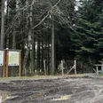
- Start: Wenholthausen hiking portal
- Destination: Wenholthausen hiking portal
You hike along the Beerenberg, come to the miniature village of Hammerkotten and hike a short distance along the Sauerland Höhenflug. Past the Lauschgeist and the Erdenklangstraße, the tour takes you back to Wenholthausen.
Good to know
Best to visit
Directions
Always follow the hiking sign W6.
Tour information
Cultural Interesting
Loop Road
Equipment
We recommend that you bring sturdy shoes and sufficient food and drink.
Directions & Parking facilities
Wenholthausen is located on the K 541.
If you are traveling by car, take the A 46 freeway to the Wennemen exit. From there, follow the L 743 in the direction of Freienohl. In Freienohl, turn left onto Freienohler Straße in the direction of Berge/Wenholthausen onto the K 541. Follow this road until you reach Wenholthausen.
You will find free parking at the Wenholthausen hiking portal at the Wennebrücke bridge. The hiking parking lot is also the starting point of your tour.
Bus route 367 runs in Wenholthausen. To get to the starting point of the tour, use the bus stop "Wenholthausen Post". From here it is only a few meters to the Wenholthausen hiking parking lot.
To the timetable information: www.rlg-online.de
With the Schmallenberger Sauerland Card you can travel free of charge by bus and train in the region.
Author
Tourist-Information Schmallenberger Sauerland
Organization
Schmallenberger Sauerland Tourismus
License (master data)

Author´s Tip / Recommendation of the author
Take a detour to the eavesdropping ghost. In the eavesdropping ghost, a large head, you can listen to the sounds of the forest.
Safety guidelines
A rescue point system has been installed in the Hochsauerland district. Rescue points can be found on the information boards at junctions and on the hiking signs.
Map
Hiking map of the Eslohe vacation region, scale: 1 : 25,000
Nearby

