


- 9:30 h
- 32.40 km
- 833 m
- 894 m
- 281 m
- 652 m
- 371 m
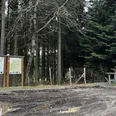
- Start: Hiking portal Wenholthausen
- Destination: Center Bad Fredeburg
Start your hike in Wenholthausen at the hiking portal. Hike over the Sauerland Höhenflug via Büemke, Kirchilpe, and above Altenilpe to Bad Fredeburg. Enjoy this beautiful and scenic hike over the Sauerland Höhenflug.
Good to know
Best to visit
suitable
Depends on weather
Tour information
Stop at an Inn
Equipment
Please wear sturdy footwear and bring enough drinks for the hike.
Additional information
Information on the Sauerland Höhenflug:
Author
Tourist-Information Schmallenberger Sauerland
Organization
Schmallenberger Sauerland Tourismus
License (master data)

Author´s Tip / Recommendation of the author
We recommend a stop for food and drink after the hike at a guesthouse in Bad Fredeburg or along the way.
Map
Hiking map of the Eslohe holiday region, scale 1:25,000!
Nearby
