On the E3 through Saxon Switzerland - Stage 3: From Bielatal to Königstein


- 3:35 h
- 12.36 km
- 305 m
- 488 m
- 114 m
- 422 m
- 308 m
- Start: Bielatal
- Destination: Kingstone
Bielatal - Panoramahöhe - Labyrinth - Bernhardstein - Rock Labyrinth - Harald Schurz Trail - Königstein Fortress - Königstein
Good to know
Pavements
- Street (4%)Asphalt (40%)Gravel (10%)Trail (15%)Path (30%)
Best to visit
- suitableDepends on weather
Directions
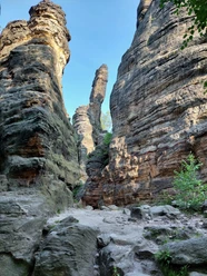
- On the route between Bielatal and Königstein, we again find numerous, ever-changing views deep into Saxon Switzerland. The focus today is on the table mountains, especially from the Bernhardstein we get a beautiful overview of these special sandstone formations. Between the table mountains there are so-called flat areas. We also get views of the next stages, as we see the Lilienstein, the Brand, the Schrammsteine and the Großer Winterberg. A short detour into the rock labyrinth offers the opportunity to get very close to the rocks before the ascent to Königstein Fortress. The stage is deliberately kept shorter to allow time to visit the fortress and its exhibition rooms. There are places to stop for refreshments and overnight accommodation in Königstein.
From the village of Bielatal, we follow the "green dot" to Panoramahöhe. From there, we head towards the labyrinth, briefly crossing the road again before entering the forest once more. On the right, we come to the panoramic view from the Bernhardstein. The descent takes us to the rock labyrinth in a short time, which we can explore on a detour. At the crossroads before the labyrinth, the E3 turns right onto Hirschstange, which we follow to the road between Königstein and Leupoldishain. On the way, there are unobstructed views of the Pfaffenstein, Lilienstein and Königstein Fortress. On the other side of the road, the Harald Schurz Trail branches off; we follow this and the Donkey Trail to Königstein Fortress. At least two hours should be allowed for a visit to the fortress. The descent from the fortress leads partly via steps into the town center of Königstein. The stage ends here, and the next stage follows with the crossing of the Elbe by ferry.
Tour information
Cultural Interesting
Equipment
- Hiking boots are recommended.
Directions & Parking facilities
- Getting thereFrom Pirna or Bad Schandau on the B172 continue via the S171 to BielatalParkingBielatal parking lot: Bernhardtstein/LabyrinthPublic transportationArrival:
Bielatal Reichstein stop
Bus routes: 245, 242, 247
Departure:
Reißiger Platz stop or Königstein S-Bahn stop line S1
Bus routes
241, 242, 244, 246
For more information and timetables , visit https://www.vvo-mobil.de/ Additional information
- On this section, the E3 is identical to the EB (Eisenach-Budapest). The paths are marked with a blue line on a white background.
Thanks to good public transport connections in the area and a well-branched network of marked hiking trails, the route can be varied or shortened in many places.
Author
Amrei Voigt (NLPFV)
Organization
Tourismusverband Sächsische Schweiz
License (master data)
Amrei Voigt (NLPFV)

Author´s Tip / Recommendation of the author
- The never-conquered Königstein Fortress is well worth a visit!
Safety guidelines
- You are in the Saxon Switzerland nature reserve on this stage. You can find out more about the protected areas on the national park's website, for example about the rules that apply there.