


- 4:54 h
- 18.21 km
- 234 m
- 279 m
- 123 m
- 314 m
- 191 m
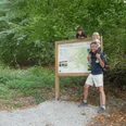
- Start: Neuenbeken Mission House
- Destination: Luise Hensel Garden House
Stage 1: Missionshaus - B64 underpass: 5.4 km
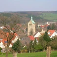
The starting point of our hike is the Missionshaus in Neuenbeken. For the first three kilometers, we can orient ourselves not only by the markings of the JSW, but also by those of the Paderborner Höhenweg.
We follow the old Amtsstraße uphill, cross the Hildesheimer Hellweg and walk uphill on the road "Buchholz". After a few bends we pass a railroad underpass. Immediately afterwards we reach a crossroads. If we turn left here for just under 100 meters, we come to the former Uhden glassworks and a pretty old half-timbered bakery.
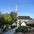
To follow the JSW, we keep straight on. Immediately after the crossroads, we turn right onto a path that leads us down to the Uhden family mausoleum. Back at the top of the path, we keep right. After a right-left bend, we come to the edge of the forest, where we turn left. After around 500 meters, we reach a crossroads where we see a raised hide. There we turn right. Our path runs a few meters from the edge of the forest through a beautiful beech forest. After a quarter of an hour, we see individual natural stones and the large oak cross of the Neuenbeken plague cemetery on our right.
A good 100 meters after this, at the edge of the forest, the old pilgrims' path and the JSW separate. We keep to the right. We cross the K1 district road and walk straight ahead across a small parking lot into the forest. After around 1.3 kilometers, at the end of the forest, we come to an asphalt path, which we follow to the left. We pass the idyllic Gottegrund, a typical dry valley on the Paderborn plateau. A quarter of an hour later, we pass the B64 underpass.
Stage 2: B64 underpass - Ellerbach Dahl: 4.5 km
200 meters further on, before a section of forest, we turn right onto the gravel path. After another 20 minutes, turn left and follow this path through a left-hand bend down into the valley. The "Pamelsche Grund - Krumme Grund" nature reserve is now on the right. We can read more about the nature reserve on an information board at the next fork in the path.
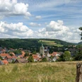
We keep to the right at the fork and walk along the asphalt path "Am Langen Hahn" with wide views over the vast landscape of the Paderborn plateau with its numerous wind turbines. Finally, we reach the Paderborn district of Dahl. We continue along the path until we reach the main road "Am Stadtberg" near the Frischmarkt Ising after a fairly steep incline. We cross this and follow the Ellersteg to the Ellerbach stream.
Stage 3: Ellerbach Dahl - Liethstaudamm: 5.1 km
Before the concreted - and mostly dry - stream bed, we turn right onto Tiefen Weg. Now we are not only on the JSW, but also on the Paderborner Karstrundweg and the Landdrostenweg. We follow the Tiefen Weg uphill until a narrow, asphalted path branches off to the left. We continue along this path above the Ellerbach valley with beautiful views. After around 250 meters, we reach the largest bench in the Paderborn region, which was erected there in 2022.
50 meters further on, at the T-junction, we turn left, walk steeply downhill for around 100 meters and turn right at the junction onto the Splittweg. We now walk along the grit path for about a quarter of an hour and see an information board about the Ellerbach after about 800 meters. About 200 meters before the end of the grit path, we come across an overview board for the Paderborn Karst Trail. At the end of the grit path, we climb quite steeply to the right on the asphalted Iggenhauser Weg until we reach the road Am Stadtberg, which connects Dahl with the town center. There we walk a few meters to the left, then turn onto the asphalt farm track. At the T-junction, we keep right. At the next opportunity, we turn left and walk down into the valley. We follow the path through the beautiful dry valley "Krumme Grund". Half an hour later, we pass under the large valley bridge of the B64 and soon reach the Liethstaudamm.
Stage 4: Liethstaudamm - Luise-Hensel-Gartenhaus: 3.2 km
The path turns left and climbs up to the southern end of the dam. We cross the turning point, keep slightly to the right and walk back down into the valley on the other side. At the bottom, we keep slightly to the left and head between the bushes onto a nature trail. Now we walk across a beautiful green area. At the end, we take the small ascent, keep diagonally to the right and walk downhill on the roughly paved path. Shortly afterwards, we pass a railroad underpass and a little later a road underpass. We find ourselves in or next to the mostly dry bed of the "Krumme-Grund-Bach" stream. We soon find ourselves on the romantic Philosophenweg. At the end of the Philosophenweg, we reach Driburger Straße at the Luise Hensel garden house. The Josef-Schmitz-Weg ends here after exactly 18.2 kilometers.
To get to the city centre from here, we follow Driburger Straße to the inner city ring road, head straight on into Giersstraße and walk purposefully towards the 93-meter-high cathedral tower.
The starting point of our hike is the Missionshaus in Neuenbeken. For the first three kilometers, we can orient ourselves not only by the markings of the JSW, but also by those of the Paderborner Höhenweg.
We follow the old Amtsstraße uphill, cross the Hildesheimer Hellweg and walk uphill on the road "Buchholz". After a few bends we pass a railroad underpass. Immediately afterwards we reach a crossroads. If we turn left here for just under 100 meters, we come to the former Uhden glassworks and a pretty old half-timbered bakery.
To follow the JSW, we keep straight on. Immediately after the crossroads, we turn right onto a path that leads us down to the Uhden family mausoleum. Back at the top of the path, we keep right. After a right-left bend, we come to the edge of the forest, where we turn left. After around 500 meters, we reach a crossroads where we see a raised hide. There we turn right. Our path runs a few meters from the edge of the forest through a beautiful beech forest. After a quarter of an hour, we see individual natural stones and the large oak cross of the Neuenbeken plague cemetery on our right.
A good 100 meters after this, at the edge of the forest, the old pilgrims' path and the JSW separate. We keep to the right. We cross the K1 district road and walk straight ahead across a small parking lot into the forest. After around 1.3 kilometers, at the end of the forest, we come to an asphalt path, which we follow to the left. We pass the idyllic Gottegrund, a typical dry valley on the Paderborn plateau. A quarter of an hour later, we pass the B64 underpass.
Stage 2: B64 underpass - Ellerbach Dahl: 4.5 km
200 meters further on, before a section of forest, we turn right onto the gravel path. After another 20 minutes, turn left and follow this path through a left-hand bend down into the valley. The "Pamelsche Grund - Krumme Grund" nature reserve is now on the right. We can read more about the nature reserve on an information board at the next fork in the path.
We keep to the right at the fork and walk along the asphalt path "Am Langen Hahn" with wide views over the vast landscape of the Paderborn plateau with its numerous wind turbines. Finally, we reach the Paderborn district of Dahl. We continue along the path until we reach the main road "Am Stadtberg" near the Frischmarkt Ising after a fairly steep incline. We cross this and follow the Ellersteg to the Ellerbach stream.
Stage 3: Ellerbach Dahl - Liethstaudamm: 5.1 km
Before the concreted - and mostly dry - stream bed, we turn right onto Tiefen Weg. Now we are not only on the JSW, but also on the Paderborner Karstrundweg and the Landdrostenweg. We follow the Tiefen Weg uphill until a narrow, asphalted path branches off to the left. We continue along this path above the Ellerbach valley with beautiful views. After around 250 meters, we reach the largest bench in the Paderborn region, which was erected there in 2022.
50 meters further on, at the T-junction, we turn left, walk steeply downhill for around 100 meters and turn right at the junction onto the Splittweg. We now walk along the grit path for about a quarter of an hour and see an information board about the Ellerbach after about 800 meters. About 200 meters before the end of the grit path, we come across an overview board for the Paderborn Karst Trail. At the end of the grit path, we climb quite steeply to the right on the asphalted Iggenhauser Weg until we reach the road Am Stadtberg, which connects Dahl with the town center. There we walk a few meters to the left, then turn onto the asphalt farm track. At the T-junction, we keep right. At the next opportunity, we turn left and walk down into the valley. We follow the path through the beautiful dry valley "Krumme Grund". Half an hour later, we pass under the large valley bridge of the B64 and soon reach the Liethstaudamm.
Stage 4: Liethstaudamm - Luise-Hensel-Gartenhaus: 3.2 km
The path turns left and climbs up to the southern end of the dam. We cross the turning point, keep slightly to the right and walk back down into the valley on the other side. At the bottom, we keep slightly to the left and head between the bushes onto a nature trail. Now we walk across a beautiful green area. At the end, we take the small ascent, keep diagonally to the right and walk downhill on the roughly paved path. Shortly afterwards, we pass a railroad underpass and a little later a road underpass. We find ourselves in or next to the mostly dry bed of the "Krumme-Grund-Bach" stream. We soon find ourselves on the romantic Philosophenweg. At the end of the Philosophenweg, we reach Driburger Straße at the Luise Hensel garden house. The Josef-Schmitz-Weg ends here after exactly 18.2 kilometers.
To get to the city centre from here, we follow Driburger Straße to the inner city ring road, head straight on into Giersstraße and walk purposefully towards the 93-meter-high cathedral tower.

Good to know
Best to visit
suitable
Depends on weather
Equipment
Hiking boots, drinks and provisions are recommended.
Directions & Parking facilities
Freeway A 33 to exit Pad.-Zentrum, then B 64 in the direction of Bad Driburg to exit Neuenbeken. Turn left onto Kreisstraße 1 (K1) towards Neuenbeken.
Starting point Missionshaus: Follow the road, in Neuenbeken turn right onto Hildesheimer Hellweg, then left onto Alte Amtsstraße.
Starting point Dunetal: Follow the road, in Neuenbeken turn right onto Hildesheimer Hellweg. Now drive about 2 kilometers on the L 755, then turn right onto the asphalt road Dune.
Parking for cars is available in the Alte Amtsstraße near the Missionshaus (navigation address: Alte Amtsstraße 64, 33100 Paderborn).
Travel by city bus (PaderSprinter)
Paderborn - Neuenbeken: Line 8
Paderborn - Dahl: Line 4
Further information: www.padersprinter.de
Paderborn - Neuenbeken: Line 8
Paderborn - Dahl: Line 4
Further information: www.padersprinter.de
Additional information
Tourist Information Paderborn
Königsplatz 10
33098 Paderborn
Tel. 05251 8812980
tourist-info@paderborn.de
Königsplatz 10
33098 Paderborn
Tel. 05251 8812980
tourist-info@paderborn.de
www.facebook.com/paderborn.tourismus
www.instagram.com/paderborn.tourismus
Literature
Paperback "Heimatwandern - Halbtages-Wanderungen im Paderborner Land, Eggegebirge und südlichen Teutoburger Wald" with 20 interesting circular tours through the local region (240 pages). Available for 15.80 euros from Paderborn Tourist Information, bookshops (ISBN: 978-3-9824645-0-3) and - free of charge - from HEFT-Zeitschriftenverlag (tel. 05251 62624).
Pocketbook "The most beautiful half-day hikes in the Paderborn region and Eggegebirge" with 20 interesting circular tours through the local region (220 pages). Available for 12.95 euros from Paderborn Tourist Information, bookshops (ISBN: 978-3-9809507-8-7) and - free of shipping costs - from HEFT-Zeitschriftenverlag (Tel. 05251 62624).
Pocketbook "The most beautiful half-day hikes in the Paderborn region and Eggegebirge" with 20 interesting circular tours through the local region (220 pages). Available for 12.95 euros from Paderborn Tourist Information, bookshops (ISBN: 978-3-9809507-8-7) and - free of shipping costs - from HEFT-Zeitschriftenverlag (Tel. 05251 62624).
Author
Tourist Information Paderborn
Königsplatz 10
33098 Paderborn
License (master data)
Tourist Information Paderborn

Nearby