Kälbersteine near Sohland a.d. Spree


- 2:05 h
- 7.06 km
- 240 m
- 218 m
- 285 m
- 483 m
- 198 m
The Kälbersteine (487 m) are the central ridge in the middle of the Upper Lusatian Mountains. On a rock massif there is a natural viewing platform with a view towards the 1000-year-old Bautzen. According to tradition, the name originated during the Thirty Years' War. At that time, the local farmers drove their cattle onto the mountain to find protection and refuge here.
A special feature, discovered by the friends of the archaeoastronomy working group as a calendrical solar observation phenomenon, can be found on the high plateau. A sight opening offers the possibility of determining the two solstices and the equinoxes. A board with a lot of interesting information provides extensive details about this granite formation.
A widely branched network of hiking trails from the surrounding villages connects the region and can be experienced from all directions of the compass.
Good to know
Pavements
Best to visit
Directions
We hike up from the reservoir in the state-recognized spa town of Sohland a. d. Spree. The car finds a parking space in front of the recreation center on the B98. This road is crossed under and the path along the idyllic lake is chosen. Past the playground, a short stretch along the Spreeradweg, which runs all the way to Berlin, the hiker follows the signposted "Waldbühne" uphill to the right. Passing the Waldbühne, which delights thousands of spectators every summer with wonderful performances, the path continues straight at the next crossroads. The adventurous hiker consistently follows the uphill signage, which can be seen from afar in yellow and black colors.
On the plateau of the Kälbersteine, the path follows a section marked with a blue stripe, the Upper Lusatian Mountain Trail, which begins in Neukirch and ends in Zittau, offering an interesting way to hike through Upper Lusatia.
Here, you can also view the mysterious rock that indicates the solstices and is therefore recognized as a kind of early calendar.
The hiking trail then continues downhill to the right along the Alte Marktstraße with a yellow stripe, which is also followed when turning right towards Ellersdorf. Wonderful views reward the effort of the ascent.
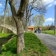
Upon reaching Ellersdorfer Straße, turn left downhill. Do not follow the paved path towards the Waldbühne but continue a bit further downhill (to Umgebindehaus-Hof) and then turn right on the hiking trail past the Drei Teiche (Three Ponds). This natural monument area is very romantic, with a great calm over the place. Continuing downhill, the Sohland reservoir appears again before the hiker, who will surely want to refresh or take a boat ride on the water. Returning to the parking lot, the starting point of the hike is reached.
Tour information
Loop Road
Stop at an Inn
Author
Touristinformation Sohland a.d. Spree
Organization
Das Landschaftswunderland Oberlausitz
License (master data)
Touristinformation Sohland a.d. Spree

Nearby