- 3:32 h
- 13.34 km
- 269 m
- 269 m
- 141 m
- 223 m
- 82 m
- Start: Rheder, parking lot on Parkweg near the brewery
- Destination: Rheder, parking lot on Parkweg
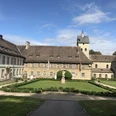
The beautiful hilly landscape of the Nethebergland and the cultural sights along the way make this hike an experience. It starts at the baroque castle barn in Rheder, where beer has been brewed for more than 300 years. In the beer garden behind the park barn, you can not only taste the beer, but also enjoy a magnificent view of the impressive willow palace. The route leads through beautiful beech forest to Gehrden. There, next to the baroque-style monastery buildings, you will find the parish church, built around 1180, which has been preserved in its Romanesque form. The tour continues over the Katharinenberg to Siddessen and then along the Nethe back to Rheder.
The hike is mainly on easy farm tracks. You can do without provisions as there are refreshment stops in Gehrden.

Waypoints
Good to know
Best to visit
Directions
Stage 1: Rheder Brewery - Gehrden Castle [6.6 km]
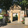
From the parking lot at the start of the park path, walk along the park path in the direction of Lindenallee. To the right and left are the farm buildings of the Rheder steam brewery, which is the full name of the Gräflich von Mengersen brewery. After a few meters along Lindenallee, we see the park barn on the left with a café and beer garden run by the brewery and the 30-metre-long and almost 10-metre-high willow palace built in 2012. On the right, we see the south side of the castle with the orangery.
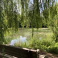
We cross the Nethe on the wooden bridge. The building on the right is the former mill, on the left is the rock cellar where beer is stored for maturing. At the turning point about 50 meters after the bridge, we turn right towards the pond (signpost: Gable 2, U, white diamond) and walk along the edge of the forest at the foot of the Sieseberg. In spring, larkspur and meadow foamwort bloom here and large areas in the forest are covered with wild garlic. We pass the castle pond and a little later the pipe pond and enjoy beautiful views of the castle and the garden.
After leaving the park through the gate pillars, we come to the K 39 district road and turn left. In the bend to the right, where we see a cross flanked by two lime trees, we head straight ahead (signpost: Gable 2). On the asphalt path, which turns into a gravel path after a few hundred meters, we walk steadily uphill along the edge of the forest. After about 25 minutes, we come to an asphalt path and keep straight ahead (signpost: Gable 2). From here, we have a wide view of the Brakel valley basin and, on a clear day, we can even make out the Köterberg, around 25 kilometers away. We walk straight into the forest (signpost: Gable 2) and follow the gently descending road through the "Sünderholz". After a quarter of an hour, we leave the forest and cross the district road K 20 after a left-right bend. The dilapidated asphalt path leads us slightly uphill in a left-hand bend into the "Mittelholz" forest. We keep straight on at a crossroads. At the crest, we ignore the path leading from the right and 100 meters further on the path branching off to the left. Shortly afterwards, we come to a fork where we turn right towards the "Zum Eichental" shelter and barbecue hut.
Immediately before the hut, we turn left and climb up the slope on a path. At the top, we see the shooting range building on the right. After a few meters we come to an asphalt path and walk straight ahead along the lawn. At about the end of the lawn, we turn right onto a grass path. This takes us into the former Hudewald forest, where some very old but also a number of young oaks grow. In earlier times, it served as a communal meadow where the small farmers of the village were allowed to graze their cattle. We stay on the grass track for just under 150 meters, then turn left onto a path and head first towards the mighty oak tree and then on towards the houses of the vacation village. A few meters to the right of the wooden house at number 18, we meet the asphalt path, which we continue on to the right. After the house at number 19, the road bends to the left and now leads along the edge of the vacation village - past the Unter den Eichen restaurant - towards Gehrden (signpost: Giebel 2).
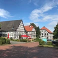
We meet the K 20, which is called Rotheweg here in the village, and follow it downhill. Immediately after the bridge over the Öse, we turn left onto the narrow gravel path. We are now on the water nature trail, which initially runs along the Ösebach for a few meters, then turns right to the Mühlengraben, which we follow to the left. Numerous information boards inform us about the fish species found here. On the right-hand side, we see the former Gehrden monastery mill dating back to 1708. After a playground, our path bends to the left, leading back towards the Öse and then along the course of the stream. After 50 meters, we reach an asphalt road, Marktstraße, and turn right. We cross the Mühlengraben bridge and about 100 meters later cross Rathausstraße. The half-timbered building with the large flight of steps and the green entrance door is the former Gehrden town hall from 1733.
A little later, the enclosing wall of the castle grounds begins on the right-hand side. We enter the castle grounds through a gate-like passage in the wall, followed by a 15-step staircase. Before doing so, however, we should definitely take a look at the Romanesque parish church, whose north portal is located to the left of the church tower.
At the top of the stairs, we turn left and walk towards the north wing of the castle. To the right is the historic pigeon tower. In good weather, the terrace of the castle restaurant invites you to linger. Looking back to the right, we discover the imposing Twelve Apostles' Linden tree just 100 meters away. According to various estimates, it is 400 to 800 years old and its trunk has a circumference of over nine meters. Strictly speaking, it consists of twelve individual winter lime trees that were planted in such a way that they grew together to form one tree.
In front of the castle, we keep left and walk along a gravel path past the church tower and the nave. This takes us onto a flagstone path and we reach a gate through which we leave the castle grounds. We now continue our walk around the church on a cobbled path, which turns into a path paved with red stones from the perimeter wall of the churchyard.
At the "Zur Alten Post" inn, we meet Rathausstraße again, cross it and walk diagonally to the right through the green area towards the Ösebrücke bridge, which we recognize by the blue railings and a stone Nepomuk figure. About 50 meters after the bridge, we turn left into the street Am Ring and turn diagonally right at house number 6 onto the path that leads up to Rosenberg - also known as Katharinenberg (signpost: Giebel 2, X2).
We walk up the hill along a beautiful avenue of old chestnut, lime and beech trees, past stations of the cross that were donated by Gehrden families after the First World War in memory of their fallen sons.
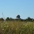
At the top, we first see St. Catherine's Chapel, built in 1668, and then a baroque wayside shrine with a depiction of events from the life of St. Catherine on both sides. The Way of the Cross finally ends at a large stone cross commemorating the fallen of the First World War. At the highest point, two benches invite you to enjoy the excellent view from the Katharinenberg.
Left past the wayside shrine, we walk onto the grass path (signpost: Gable 2, X2), which is initially lined with bushes and then crosses a pasture. Here we come to a section of the Gehrden fruit nature trail. Shortly after passing a gate, we reach a T-junction where we turn left (signpost: Gable 2, X2).
At the end of the grassy gravel path, we turn right and walk down the asphalt path through a few bends into the so-called Tiefental valley. At the crossroads, keep right and walk along the asphalt path through the Tiefental to Siddessen. Over the next 2 kilometers, we ignore all the turn-offs. We pass the town sign, see the sports field on the left and head towards the church. We follow the bend to the right and learn that we are on the path to Tiefental (signpost: Gable 2, X2). This remains the case when we turn left after the house with the number 14. Shortly afterwards, the eyelet flows to our right, and on our left we see the neo-Gothic church and the soldiers' memorial.
Stage 3: Siddessen church - Rheder brewery [2.4 km]
Turn left at the T-junction. The baroque portal of the village's former chapel, built in 1668, forms the entrance to the church square. After 50 meters, we turn right onto Klinkenhahn. From house number 7, we are on a cycle and footpath (signpost: Gable 2, X2). Looking to the right, we see the mouth of the Öse into the Nethe below the B 252 road bridge. The cycle and footpath now gains some height, allowing us to enjoy beautiful views over the Nethe valley. At the point where the cycle path turns right down to the B 252, we head straight on along a beaten track (signpost: Gable 2). After about 70 meters, we meet a hiking trail, keep right and continue our tour through the beech forest. In spring, huge areas in this area are overgrown with wild garlic.
At the Nethe weir, where the Mühlengraben is diverted, a narrow path takes us down to the footbridge over the Mühlengraben. Before we follow the path that runs between the Nethe and the Mühlengraben, we briefly cross the weir bridge to take a look at the fish ladder, the "Meander Pass". Its function is explained on a board.
As we walk along the embankment between the Mühlenbach and the Nethe (signpost: Gable 2), we see some ponds on the right-hand side that belong to the brewery's biological sewage treatment plant. A few minutes later, we reach the rock cellar and the former mill. We keep to the right and have almost reached the end of our tour when we pass the Nethebrücke bridge.
We should not leave Rheder without taking a look at the inner courtyard of the castle and the baroque garden. The baroque parish church of St. Katharina is also worth a visit, as it was designed by two important Westphalian architects: Gottfried Laurenz Pictorius is credited with the design of the building and his successor Johann Conrad Schlaun with the interior design of the church.
Tour information
Loop Road
Stop at an Inn
Directions & Parking facilities
Author
Karl Heinz Schäfer
Organization
Tourist Information Paderborn / Verkehrsverein Paderborn e.V.
License (master data)
Karl Heinz Schäfer

Author´s Tip / Recommendation of the author
Nearby