


- 4:15 h
- 14.45 km
- 346 m
- 403 m
- 169 m
- 333 m
- 164 m
- Start: Mission house in Paderborn-Neuenbeken
- Destination: Mission house in Paderborn-Neuenbeken
Passing Hindahls Kreuz, the trail continues gently uphill at first, then descends into the charming Beketal valley. After crossing the Beke and the adjacent country road, things become mysterious when you pass an almost 100-metre-long railroad underpass. This is followed by a saddle and soon after you reach the Dune Valley with the Little Viaduct.
The path now climbs quite steeply for around 10 minutes up the northern slope of the Dune Valley to the viewing platform built in 2014, up to which you have to ascend around 50 meters. From the platform, there is a magnificent view back to the Little Viaduct and the Beketal valley.
From the platform, the blue signs of the Paderborn High Trail cross-connection now indicate the direction. After a good 20 minutes in the forest, you will reach the former Uhden glassworks and the old bakery.
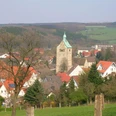
The trail descends under the railroad underpass into the village and shortly afterwards the hike ends back at the Neuenbeken mission house.
The Paderborn High Trail was certified by the German Hiking Association in 2014, 2017 and 2020 as a "Qualitätsweg Wanderbares Deutschland".

Good to know
Pavements
Best to visit
Directions
The starting point of our hike is the entrance to the convent of the Missionary Sisters of the Precious Blood. We cross the Alte Amtsstraße and take the street An der Bischofsmühle. We cross the Beke bridge and turn left at the end of the path. After about 50 meters, a footpath branches off to the right, which leads up the steep slope in a few serpentines. At the top, continue straight ahead until you reach Horner Hellweg. Follow this to the right. After about 250 meters, immediately after the small parking lot with the recycling containers, we turn right onto a hiking trail. A signpost to the tree house also shows us the direction here. At the fork, which we reach after a few meters, we choose the left alternative. Our hiking trail now climbs slightly up to the 224-metre-high Ziegenberg. To the left, we occasionally have good views of Bad Lippspringe and the Senne. At a crossroads, we keep straight on. A little further on, we see the Neuenbeken tree house on the slope to the right, which is used by schools for "lessons in the forest".
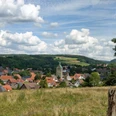
Our path continues for another 800 meters through the forest - parallel to the asphalted Horner Hellweg, until it finally joins it. We continue to the right. Shortly afterwards, an asphalt path coming from Bad Lippspringe joins it from the left. About 100 meters later, we turn right, pass the barrier and after a few minutes reach the Papenberg viewpoint, from where we can enjoy a wide view over Neuenbeken and Benhausen as far as Paderborn and the Hellwegebene. A picnic group and a landscape lounger invite you to take a break here.
Stage 2: Viewpoint - Beketal quarry: 5.3 km
About 100 meters further on, at the edge of the forest, the asphalt path turns into a gravel path. Keep left at the fork. Around 300 meters further on, a short path branches off to the right to the small sinkhole on the Hanstein. An information board at the side of the path marks the spot.
We follow the forest path. In a small dip, a path joins from the right at an acute angle. The path then climbs slightly. At the next fork, we keep left and follow the gravel road. After about 300 meters, we see an iron cross on a stone pedestal on the right, "Hindahls Kreuz", as well as an information board for the Paderborn High Trail. Here we turn right and walk along this straight road for about 700 meters until a path branches off to the right, which is blocked by a red and white barrier. We turn right and shortly afterwards reach the hiking hut of the Eggegebirgsverein Neuenbeken section. The hut is closed, but the benches under the canopy are a good place to take a break.
We follow the path through the forest and come to a road, which we follow to the left. After about 300 meters, in the right-hand bend of the road, we keep straight ahead and climb a little uphill on a gravel path. At the top, turn right. After about 200 meters, we follow the bend to the right. We now walk downhill along the slope on the relatively wide forest path. At a fork, we choose the right-hand path, which initially runs along the slope at roughly the same height. After negotiating a left-hand bend, we reach a fork where we keep left. We walk downhill. This is followed by a left turn of almost 180 degrees, after which we reach a crossroads where we turn right. We walk through several bends along the slope. At first our path descends, but then rises again slightly and then descends again. Occasionally - when the trees are not leafy - we can see the small viaduct on the other side of the Beketal. After a 180-degree left-hand bend, a well-maintained gravel path takes us down into the Beketal valley. On the left, we see the former quarry at Hanstein, where we can clearly see the stratification of the limestone bedrock. Here, another picnic area invites you to take a break.
Stage 3: Beketal quarry - Dunetal: 3.6 km
We ignore the road branching off to the right and walk along the edge of the forest through the Beketal for around 1.3 kilometers. Then we turn right, cross the Beke bridge and reach the country road, which we cross carefully. We descend the steps and continue to the right. After just under 100 meters, we turn left onto the gravel path, which is closed off by a barrier. We pass the long, dark railroad embankment tunnel and turn right onto the wide forest path about 200 meters further on. This first leads uphill, then downhill and finally ends in the Dune Valley. Here we hike towards the Dune Viaduct and the refuge.
4th stage: Dune Valley - Mission House: 2.9 km
We cross the asphalt path and follow the path behind the refuge, which leads us up the slope in a few hairpin bends. We now have around 50 meters of altitude to overcome. At the top, we come to a junction where we can choose between three other paths. We turn right and after a few minutes reach the viewing platform, which was built in 2014 and offers an impressive view of the viaduct and across the Beketal valley.
We now follow the gravel forest path for a good kilometer, which runs more or less close to the railroad tracks. Shortly after we have asphalt under our shoes again, we see the octagonal former Uhden glassworks on the left, where glassware was produced from 1829 to 1911. We reach a crossroads where we turn right. However, we should first take a look at the Uhden family mausoleum made of limestone, which we can reach by entering the culvert on the corner of the fence.
We then walk through the railroad underpass, keep left at the T-junction and follow Buchholz Street downhill to the main road, Hildesheimer Hellweg. There we head straight on into Alte Amtsstraße. We can already see the buildings of the convent of the Missionary Sisters on the left-hand side and shortly afterwards reach our starting point.
Tip: The Franz Pfanner guest house at the Neuenbeken Mission House also offers overnight accommodation and refreshments on Saturdays and Sundays from 2.30 to 5.00 pm (groups can also visit at other times by prior arrangement on 05252 96500).
.
Tour information
Loop Road
Premium Trail "Wanderbares Deutschland"
Equipment
Directions & Parking facilities
Autobahn A 33 to exit Pad.-Zentrum, then B 64 in the direction of Bad Driburg to exit Neuenbeken. Turn left onto Kreisstraße 1 (K1) in the direction of Neuenbeken.
Starting point Missionshaus: Follow the road, in Neuenbeken turn right into Hildesheimer Hellweg, then left into Alte Amtsstraße.
The city bus line 8 (PaderSprinter) runs between Paderborn and Neuenbeken, the destination stop is "Klostergarten".
The regional bus 452 connects Neuenbeken with Altenbeken and Bad Lippspringe. The destination stop is "Klostergarten".
Further information on how to get there by city bus can be found at www.padersprinter.de or by calling 05251 6997222.
Further information on how to get there by regional bus can be found at www.fahr-mit.de or by calling 05251 2930400.
Additional information
Königsplatz 10
33098 Paderborn
Tel. 05251 8812980
tourist-info@paderborn.de
www.paderborn.de
www.facebook.com/paderborn.tourismus
www.instagram.com/paderborn.tourismus
Literature
Pocketbook "The most beautiful half-day hikes in the Paderborn region and Eggegebirge" with 20 interesting circular tours through the local region (220 pages). Available for 12.95 euros from Paderborn Tourist Information, bookshops (ISBN: 978-3-9809507-8-7) and - free of shipping costs - from HEFT-Zeitschriftenverlag (Tel. 05251 62624).
Author
Karl Heinz Schäfer
Organization
Tourist Information Paderborn / Verkehrsverein Paderborn e.V.
License (master data)
Karl Heinz Schäfer

Author´s Tip / Recommendation of the author
By the way: Take a look at the Facebook page of the Paderborn High Trail: www.facebook.com/paderbornerhoehenweg
Map
Nearby