Plauen circular hiking route - stage 4: PLAMAG - Reusa


- 4:55 h
- 18.57 km
- 167 m
- 236 m
- 315 m
- 454 m
- 139 m
- Start: Kauschwitz settlement
- Destination: Tram end stop Reusa, line 4
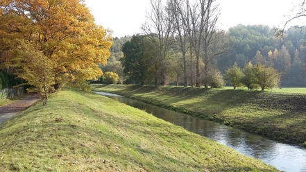
Points of interest: rest area "Three Oaks" (Bürschelweg) – view over the Neundorfer meadows, Jewish cemetery at Tannenhof 7, rest area with log cabin in the city forest, Devil's Pulpit (Grünstein rock), detour to the Elster valley bridge (second largest brick bridge in the world), wild romantic Nymphental, NSG Elsterhang near Röttis, Thößehäuser and Rosengraben - forest area with three Rosengräber (passage to Pfaffenmühle and the Elster valley)
Good to know
Pavements
Best to visit
Directions
Marking white-yellow-white
Kauschwitz settlement – Bürschelweg – to the old racecourse – crossing Pausaer Str. (B92) – Tannenhof – railway underpass – right turn onto Oberjöhnitzer Weg towards Waldgrün – forest path along the railway into the city forest – at Essigsteig turn left through the city forest to Seumestraße – crossing the railway line – left along the railway to footbridge – forest path to Pfaffenmühle – beside Kaltenbach to Nymphental – detour left to Devil's Pulpit – Elster riverside path back southwards to Pfaffengutstraße – Elster riverside path to the roundabout – roundabout forest path up right to the grave of the unknown soldier – forest path to Rosengrabenstraße – street "An den Thößehäusern" – forest path to Elster riverside path – right uphill to Pietzschebachweg – Friesenweg – crossing railway/Weiße Elster – crossing Möschwitzer Str. – at Friesenbach – Langenberggasse – left – path to Friesenbach – forest path to Waldfrieden – underpass B173 – along B173 to Semmelweisstraße – Damaschkestraße – crossing Kleinfriesener Str. – tram end stop Reusa
Tour information
Loop Road
Directions & Parking facilities
Additional information
Tourist Information Plauen, Tel: 03741 2911027
Places to eat:
Pfaffenmühle Jößnitz, Pfaffenmühlenweg 18, Tel.: 03741 - 525772, Wed. and Thu. closed
Lochbauer farm Tel: 03741 526641
Links:
http://www.echt-vogtland.de/katalog/objekt_blatt.php?objekt_ID=109
Author
Anika Seidel
Organization
Vogtland - Sinfonie der Natur
License (master data)
Anika Seidel

Author´s Tip / Recommendation of the author
Thößehäuser and Rosengraben
"Thößehäuser" was named after the buyer of the settlement in 1731. The forest area with the three Rosengräben is a popular passageway to Pfaffenmühle and the Elster valley with Lochbauer. South of the upper Rosengraben is a burial mound from the late Bronze Age.
Pfaffenmühle
The excursion restaurant Pfaffenmühle was opened in 1884. It is located in a beautiful forest landscape in the valley bottom of the Kaltenbach and just before its entry into the Nymphental. The 1.3 km long narrow valley section of the Kaltenbach belongs to the NSG "Elsterhang near Röttis" and carries the popular name "Nymphental." At the valley exit to the Weiße Elster is the "Devil's Pulpit," a small rock formation made of diabase. On the right side of the Nymphental is a mine tunnel portal from the "Saxonia-Bavaria" mine, which still recalls the mining of brown iron and spar ores in the last century.
Lochbauer
The path leads upriver on the Elster to the "Lochbauer," a protected Vogtland farmhouse built in 1648 after the end of the Thirty Years' War.
Pfaffengut
Not far from Lochbauer and the circular hiking route is the Vogtland Environmental and Nature Conservation Center, Pfaffengut Plauen, an ecological education and meeting place. Visits and guided tours are possible (see Pfaffengut Plauen brochure).
Path of Trees
This educational trail is located on the Elster riverside path between Pfaffengut, Lochbauer, and Devil's Pulpit.
Tip: The Plauen circular hiking route can be shortened in the area Pfaffengutstraße – Chrieschwitz – Reusa – Südvorstadt – Straßberg.
Nearby


Download GPX file