Unterleiten via Schliersberg and Kalkgraben


- 3:00 h
- 9.76 km
- 383 m
- 388 m
- 777 m
- 1,159 m
- 382 m
- Start: Train station, Schliersee
- Destination: Train station, Schliersee
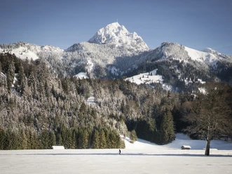
The small local mountain of Schliersee can also be climbed with appropriate equipment even with lots of snow. With moderate ascent, the route leads on forest roads through wonderfully snow-covered forest before reaching open terrain again toward the end of the round. Once you have passed the highest point, you repeatedly get a magnificent view of Lake Schliersee and the surrounding, higher mountains.
Good to know
Best to visit
- suitableDepends on weather
Tour information
Familiy-Friendly
Loop Road
Loop Road
Stop at an Inn
Author
Regionalentwicklung Oberland
Organization
Alpenregion Tegernsee Schliersee
License (master data)

Nearby
Download GPX file